Filter: Categories of Wisconsin Historical Images
Filter: FORMAT_TYPE of prints, photomechanical
Filter: County of Washington
Filter: Subject of cities and towns
Filter: Categories of Wisconsin Historical Images
Filter: FORMAT_TYPE of prints, photomechanical
Filter: County of Washington
Filter: Subject of cities and towns

| Date: | 1879 |
|---|---|
| Description: | Bird's-eye map of Hartford. |

| Date: | 1878 |
|---|---|
| Description: | Bird's-eye map of Kewaskum. Includes a list of hotels, churches, post office, railroad depot, etc. |

| Date: | 1892 |
|---|---|
| Description: | Bird's-eye view of West Bend, looking west. Milwaukee River flows across image just below center, with fairgrounds at bottom right and Maple street at top ... |
| Date: | 1900 |
|---|---|
| Description: | View of unpaved Main Street, with horse-drawn vehicles along the curbs. |
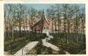
| Date: | 1910 |
|---|---|
| Description: | View of the steps leading up to the Carmelite Church of Our Lady, Help of Christians. Caption reads: "Steps Leading to Church, Holy Hill, Wis." |
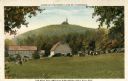
| Date: | 1920 |
|---|---|
| Description: | View of Holy Hill, with a field and the Hillside Hotel in the foreground. Captions read: "America's Favorite Place of Pilgrimage" and "The Holy Hill and Hi... |
| Date: | 1920 |
|---|---|
| Description: | View of the Carmelite Fathers' home on Holy Hill. Caption reads: "Home of the Carmelite Fathers, Holy Hill, Wis." |

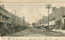
| Date: | 1905 |
|---|---|
| Description: | Elevated view towards the right side of Main Street. Caption reads: "Main Street, East Side, Hartford, Wis." |
| Date: | 1910 |
|---|---|
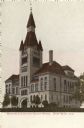
| Description: | View towards the court house. Caption reads: "Washington County Court House, West Bend, Wis." |

| Date: | 1910 |
|---|---|
| Description: | The Washington County Court House. Caption reads: "Washington County Court House, West Bend, Wis." |

| Date: | 1910 |
|---|---|
| Description: | View of West Bend featuring the Washington County Court House in the distance. Caption reads: "South View, West Bend, Wis. Showing Court House and Jail." |
| Date: | 1918 |
|---|---|
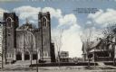
| Description: | A Catholic Church in West Bend. Caption reads: "Catholic Church, Parsonage and Sister Home, West Bend, Wis." |

| Date: | 1915 |
|---|---|
| Description: | Plat map of Polk township in Washington County. |
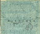
| Date: | 1859 |
|---|---|
| Description: | Detail of section 5 of the Washington County map showing only Hartford. |

| Date: | |
|---|---|
| Description: | Letterhead of the Kewaskum Mutual Fire Insurance Company of Washington County, Wisconsin, with a Native American man wearing buckskin clothes and leggings ... |
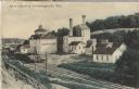
| Date: | 1910 |
|---|---|
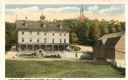
| Description: | Postcard of the Stork Brewery facilities. The image includes the brewery buildings along a hillside and railroad tracks in the foreground. There is a sign ... |

| Date: | |
|---|---|
| Description: | Colorized postcard view of the Storck Brewery in Schleisingerville (now Slinger). The brewery buildings are along a hillside, and railroad tracks are in th... |

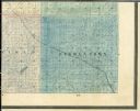
| Date: | 1859 |
|---|---|
| Description: | This 1859 map of Washington County, Wisconsin, shows the township and range grid, towns, sections, landownership and acreages, cities and villages, roads, ... |
If you didn't find the material you searched for, our Library Reference Staff can help.
Call our reference desk at 608-264-6535 or email us at: