 Filter: Categories of Wisconsin Historical Images
Filter: FORMAT_TYPE of prints, photomechanical
Filter: County of Walworth
Filter: Categories of Wisconsin Historical Images
Filter: FORMAT_TYPE of prints, photomechanical
Filter: County of Walworth

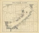
| Date: | 1930 |
|---|---|
| Description: | Shows roads, fire stations, golf course, and accommodations around Delavan Lake. "The drive around the lake is divided into zones from 0 to 900 as shown. P... |

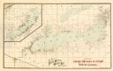
| Date: | 1910 |
|---|---|
| Description: | Map shows routes, post offices, houses, churches, roads, and schools."June 1, 1910. E.G."Blue line print."Walworth Co., Wis. 451" -- bottom margin. |

| Date: | 1939 |
|---|---|
| Description: | This map of Walworth County, Wisconsin, shows the township and range grid, sections, cities and town, and lakes and streams in the county. It lacks the key... |

| Date: | 1939 |
|---|---|
| Description: | This map of Walworth County, Wisconsin, shows the lakes and streams flowing into the Fox River and the lakes and streams flowing into the Rock River. The d... |
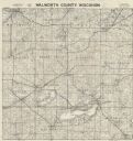
| Date: | 1956 |
|---|---|
| Description: | Map shows townships and sections, landownership and acreages, roads, schools, churches, and cemeteries. |
| Date: | 1930 |
|---|---|
| Description: | Shows land ownership by name, roads, and highways. Includes manuscript annotations. |

| Date: | 1966 |
|---|---|
| Description: | This 1966 map shows topography, roads, highways, golf courses, government buildings, and businesses around Delavan Lake in Walworth County, Wisconsin. Incl... |
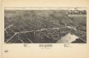
| Date: | 1884 |
|---|---|
| Description: | This map is a Birdseye view of Delavan, Wisconsin. At the bottom of the map are points of interest that correspond to numbers on the map. Many of the stree... |
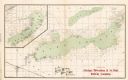
| Date: | 1902 |
|---|---|
| Description: | A map of Lake Geneva and Lake Delavan, also including Lake Como. |
| Date: | 1907 |
|---|---|
| Description: | A map of Lake Geneva and Lake Delavan, including Lake Como. |

| Date: | 1850 |
|---|---|
| Description: | This map of Geneva shows lots and acreages, reserved land, and public squares. Streets and Lake Geneva are labeled. The map includes manuscript annotations... |

| Date: | 1959 |
|---|---|
| Description: | This map of Lake Geneva has relief shown by contours and water depths shown by isolines. The map includes an index of schools, churches, public services, i... |

| Date: | 1930 |
|---|---|
| Description: | This map has relief shown pictorially and shows plat of the city, block numbers, land ownership by name, local streets, railroads, mill pond, and part of G... |

| Date: | 1966 |
|---|---|
| Description: | The map shows streets, wells, school land, parks, cemeteries, railroads, and the Delbrook Golf Course. The bottom of the map reads: "January 11, 1962 May 2... |
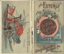
| Date: | 1902 |
|---|---|
| Description: | Front and back of 8-page foldout color brochure. Front cover advertises the "All Steel Folding Platform Binder & Mower." Back cover features a horizontal i... |
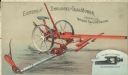
| Date: | 1902 |
|---|---|
| Description: | Inside half-page spread of foldout brochure. Features an illustration of the Esterly Enclosed Gear Mower showing Raising Device. Includes an inset on botto... |

| Date: | 1902 |
|---|---|
| Description: | Full-size inside spread of foldout brochure. Features an illustration of the Esterly Steel Binder. Includes the phrase: "Folding platform / no trucks requi... |
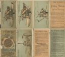
| Date: | 1902 |
|---|---|
| Description: | Front of 8-page foldout brochure. Includes 4 illustrations of machinery, including the Esterly Steel Binder, Canvas Bundle Carrier, Folding Platform or Tru... |
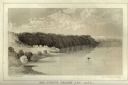
| Date: | 1856 |
|---|---|
| Description: | Lithographic view of a man in a canoe on Big-Foot's Lake (modern day Lake Geneva) with a small settlement on a bluff overlooking the lake. A group of birds... |

| Date: | 1858 |
|---|---|
| Description: | This map is hand-colored and mounted on cloth and shows lot and block numbers and dimensions, landownership, streets, railroads, selected buildings, fair g... |
If you didn't find the material you searched for, our Library Reference Staff can help.
Call our reference desk at 608-264-6535 or email us at: