 Filter: Categories of Wisconsin Historical Images
Filter: FORMAT_TYPE of prints, photomechanical
Filter: County of Walworth
Filter: Categories of Wisconsin Historical Images
Filter: FORMAT_TYPE of prints, photomechanical
Filter: County of Walworth

| Date: | 1916 |
|---|---|
| Description: | Southeastern Wisconsin which lies east of Whitewater and south of Port Washington. |
| Date: | |
|---|---|
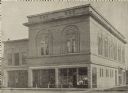
| Description: | Exterior view of the Elkhorn Public Library and a larger, two-story, brick building, with a storefront on the first floor. The Elkhorn Public Library is th... |

| Date: | |
|---|---|
| Description: | Engraving of Wisconsin Institute for Deaf and Dumb. A man in a horse-drawn carriage and another rider on horseback travel along the street in the foregroun... |

| Date: | 1908 |
|---|---|
| Description: | Angled view of the left side of a residential street lined with trees, probably taken in early spring. The home of A.H. Allyn is on the left. A covered fou... |
| Date: | 1873 |
|---|---|
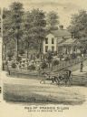
| Description: | Engraved view of the home of Francis Dillon. A woman rides on the road in front of the home in a horse-drawn carriage. A woman stands on the porch of the h... |
| Date: | 1907 |
|---|---|
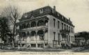
| Description: | View of the Morris Pratt Institute, a mansard-style structure. Caption reads: "Morris Pratt Institute, Whitewater, Wis." |
| Date: | |
|---|---|
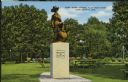
| Description: | View of the Andy Gump statue in Flat Iron Park. Picnic tables, flowers, and trees are in the background. Caption reads: "Andy Gump Statue, Flat Iron Park, ... |
| Date: | 1936 |
|---|---|
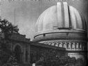
| Description: | A view of Yerkes Observatory at Williams Bay, Lake Geneva. It was the "largest refracting telescope in the world," according to "Wisconsin: A Guide To The ... |

| Date: | 08 1909 |
|---|---|
| Description: | View of trees and dirt road in Oak Park. Caption reads: "Oak Park, Army Lake, Wis." |

| Date: | |
|---|---|
| Description: | Letterhead of the Wisconsin School for the Deaf in Delavan, Wisconsin, with a background image of an elevated view of the school? and surrounding grounds p... |

| Date: | 1938 |
|---|---|
| Description: | Label submitted to the state of Wisconsin for trademark registration. "Cream Top Beer, Whitewater Brewing Co." Pictured on the label is a man sitting at a ... |

| Date: | 1898 |
|---|---|
| Description: | A hydrographic map of Lake Geneva that includes 15 cross sections of the depths at various points as well as a line running the length of the lake from Gen... |
| Date: | |
|---|---|
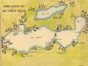
| Description: | A color, pictorial map that shows sites related to Native American villages, sites, cemeteries in the area around the lakes Geneva and Como in Walworth Cou... |
| Date: | 1840 |
|---|---|
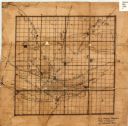
| Description: | This 19th century manuscript map shows the roads and proposed routes, villages, and lakes and streams in Walworth County, Wisconsin. |

| Date: | 1896 |
|---|---|
| Description: | This late 19th century map of Walworth County, Wisconsin, shows the township and range grid, towns, sections, villages and post offices, roads, railroads, ... |

| Date: | 1900 |
|---|---|
| Description: | This 1900 map of Walworth County, Wisconsin, shows the township and range grid, towns, sections, landownership and acreages, rural residences, cities and v... |

| Date: | 01 01 1935 |
|---|---|
| Description: | This 1935 map of Walworth County, Wisconsin, shows the township and range grid, towns, sections, cities and villages, highways and roads, railroads, school... |
| Date: | 1898 |
|---|---|
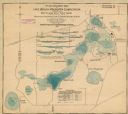
| Description: | This map shows the contour depths of Lake Beulah, Booth Lake, and Army Lake (labeled East Troy Lake on the map) in Walworth County, Wisconsin, and includes... |

| Date: | 1907 |
|---|---|
| Description: | Shows post offices, railroads, country clubs, and land ownership by name. |

| Date: | 1898 |
|---|---|
| Description: | This map shows the contour depths of Delavan Lake and the Lauderdale Lakes in Walworth County, Wisconsin, and includes nine cross sections of the lakes. Ro... |
If you didn't find the material you searched for, our Library Reference Staff can help.
Call our reference desk at 608-264-6535 or email us at: