Filter: Categories of Wisconsin Historical Images
Filter: FORMAT_TYPE of prints, photomechanical
Filter: County of Vilas
Filter: Categories of Wisconsin Historical Images
Filter: FORMAT_TYPE of prints, photomechanical
Filter: County of Vilas
| Date: | |
|---|---|
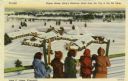
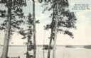
| Description: | Five people are standing at a fence rail looking down at King's Gateway Hotel. Caption reads: "Winter View at King's Gateway Hotel from the Top of the Ski ... |

| Date: | 1923 |
|---|---|
| Description: | Vilas County. Published by Chicago, Milwaukee, and St. Paul Ry. |
| Date: | 1958 |
|---|---|
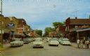
| Description: | View down center of street in downtown Eagle River, with traffic, pedestrians, and automobiles parked along the curb. There are storefronts and signs on bo... |
| Date: | |
|---|---|
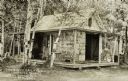
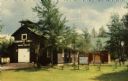
| Description: | Exterior view of the Birch Cottage surrounded by trees. There is a cushioned porch swing and other outdoor furniture on the rustic porch which wraps around... |
| Date: | |
|---|---|
| Description: | Colorized postcard of Boulder Lake. Pine trees are in the foreground and islands are below in the background. Caption reads: "Boulder Lake at Camp Manitowi... |
| Date: | 08 22 1964 |
|---|---|
| Description: | Colorized postcard of the Community Church with many trees surrounding it. |
| Date: | 1959 |
|---|---|
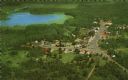
| Description: | Color postcard of an aerial view of town. There is a lake in the background in the upper left. |
| Date: | |
|---|---|
| Description: | Color postcard of the Community Church with many trees surrounding it. |
| Date: | 1947 |
|---|---|
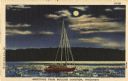
| Description: | Colorized postcard of a sailboat in the moonlight. Text below reads: "Greetings From Boulder Junction, Wisconsin." |

| Date: | |
|---|---|
| Description: | Letterhead of Denton House of Eagle River, Wisconsin, with a profile view of a fish printed in brown ink across nearly the entire width of the page, and th... |

| Date: | |
|---|---|
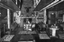
| Description: | Postcard of an empty bar and lounge. In the foreground are a number of circular seating areas of booths along a mirrored wall. The bar runs along the right... |

| Date: | 1926 |
|---|---|
| Description: | This Wisconsin Conservation Commission map from the 1920s shows roads, railroads, campsites, lookout towers, and privately owned lands in Northern Forest S... |

| Date: | 1933 |
|---|---|
| Description: | This 1933 Wisconsin Conservation Dept. map shows roads, railroads, trails, lakes and streams, and the Trout Lake Game Refuge in Northern State Forest (whic... |

| Date: | 1908 |
|---|---|
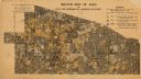
| Description: | This 1908 map shows the town and range grid, sections, cities and villages, acreages, settlers, schools, wagon roads, railroads, saw mills, and lakes, stre... |

| Date: | 1914 |
|---|---|
| Description: | This 1914 map shows the soil types in Vilas County, Wisconsin, and adjoining areas in Oneida, Forest, and Iron counties. Also depicted are the township and... |
| Date: | 1920 |
|---|---|
| Description: | This early 20th century map shows the soil types in Vilas County, Wisconsin, and adjoining areas in Oneida, Forest, Iron, and Price counties. Also depicted... |

| Date: | 1936 |
|---|---|
| Description: | These two maps of the Town of Conover, Vilas County, Wisconsin, show private land holdings of a section or more as of 1927 and public lands in 1936. Acreag... |

| Date: | |
|---|---|
| Description: | This map of Vilas County, Wisconsin, from the first half of the 20th century, shows the township and range grid, towns, sections, cities and villages, road... |

| Date: | 1933 |
|---|---|
| Description: | This mid-20th century map shows the township and range grid, towns, sections, cities and villages, roads, railroads, and lakes and streams in Vilas County,... |
If you didn't find the material you searched for, our Library Reference Staff can help.
Call our reference desk at 608-264-6535 or email us at: