 Filter: Categories of Wisconsin Historical Images
Filter: FORMAT_TYPE of prints, photomechanical
Filter: County of Trempealeau
Filter: Categories of Wisconsin Historical Images
Filter: FORMAT_TYPE of prints, photomechanical
Filter: County of Trempealeau
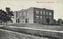
| Date: | 1920 |
|---|---|
| Description: | Exterior view of the two-story brick High School building with basement. A bare flagpole is on the roof. Caption reads: "High School, Arcadia, wis." |

| Date: | 1907 |
|---|---|
| Description: | View down Main Street, with a hotel on the left side and horse-drawn wagons on the unpaved street. Pedestrians are on the sidewalks. Caption reads: "Main S... |
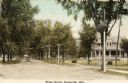
| Date: | 1910 |
|---|---|
| Description: | View down unpaved residential street with a large house on the right. An automobile is coming up the street. Caption reads: "Ridge Street Galesville, Wis." |
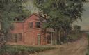
| Date: | 1931 |
|---|---|
| Description: | Drawing of the Melchoir House, which was a popular hostelry and brewery operated by Jacob Melchoir. It later became an Indian boarding house. |

| Date: | |
|---|---|
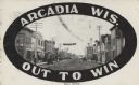
| Description: | Color postcard of shops and businesses along Main Street. Caption reads: "Main Street, Arcadia, Wis." |

| Date: | 06 07 1916 |
|---|---|
| Description: | View looking down Owen Street. A church steeple i on the right, partly obscured by trees. Caption reads: "Owen Street, Arcadia, Wis." |
| Date: | |
|---|---|
| Description: | Colorized postcard of the Trempealeau River Bridge. A lamppost is in the foreground, and buildings, including a church, are in the background. Caption read... |
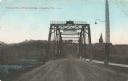
| Date: | 01 03 1914 |
|---|---|
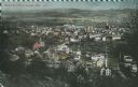
| Description: | Elevated view of downtown and the Trempealeau River. Caption reads: "Bird's [sic] Eye View, Arcadia, Wis." |
| Date: | |
|---|---|
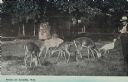
| Description: | A man is watching deer eating grass. There is also a turkey on the right. Caption reads: "Scene at Arcadia, Wis." |
| Date: | 07 29 1909 |
|---|---|
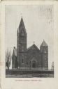
| Description: | Exterior view of the front entrance to Our Lady of Perpetual Help Catholic Church. A bare tree is on the left and a fence lines the walkway to the church i... |
| Date: | 07 29 1909 |
|---|---|
| Description: | View of Main Street. Shops and businesses line both sides of the street including a hotel, city livery and laundromat. There are pedestrians and horse-draw... |
| Date: | 07 1911 |
|---|---|
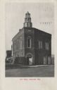
| Description: | Exterior view of the front entrance on a corner of the two-story brick City Hall. A horse-drawn wagon is visible on the far left. Caption reads: "City Hall... |

| Date: | 08 20 1909 |
|---|---|
| Description: | Exterior of the one-story brick Carnegie Library. |
| Date: | |
|---|---|
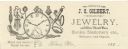
| Description: | Letterhead of J.O. Gilbert of Blair, Wisconsin, a jewelry and silver dealer who also dealt in books, stationery, and tobacco. Features a pocket watch with ... |

| Date: | 1929 |
|---|---|
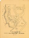
| Description: | This 1929 topographic map of Trempealeau County, Wisconsin, shows the topography, lakes, streams and wetlands, township and range grid, sections, cities an... |
| Date: | 1900 |
|---|---|
| Description: | This maps shows part of Galesville, Trempealeau County, Wisconsin. The map shows lots for sale, local streets, and part of Lake Marinuka. Lots are numbered... |

| Date: | 1854 |
|---|---|
| Description: | This map is mounted on cloth and shows lot and block numbers, streets, additions, and public squares. Also included is information on Trempealeau, an inset... |

| Date: | 1955 |
|---|---|
| Description: | This blue line print shows streets, fair grounds, schools, parks, and a cemetery. Streets, points of interest, and Lake Marinuka are labeled. The middle le... |
| Date: | 11 11 1918 |
|---|---|
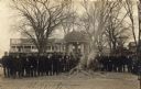
| Description: | Crowd of men and young boys gathered around a smoldering pile of ash and scraps in the Galesville Town Square. The burned items were most likely German boo... |

| Date: | 1920 |
|---|---|
| Description: | This blue print map shows landownership between 1913 and 1916, topography, railroads, and roads. The map covers the vicinity of Perrot State Park. |
If you didn't find the material you searched for, our Library Reference Staff can help.
Call our reference desk at 608-264-6535 or email us at: