 Filter: Categories of Wisconsin Historical Images
Filter: FORMAT_TYPE of prints, photomechanical
Filter: County of St. Croix
Filter: Subject of human settlements
Filter: Categories of Wisconsin Historical Images
Filter: FORMAT_TYPE of prints, photomechanical
Filter: County of St. Croix
Filter: Subject of human settlements
| Date: | |
|---|---|
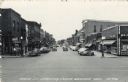
| Description: | View looking south down Main Street, which is lined with commercial business. Automobiles are parked at an angle on both sides of the street. Caption reads... |
| Date: | |
|---|---|
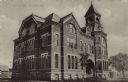
| Description: | Exterior view from street towards the high school. A date stone above a second floor window reads: "Erected A.D. 1887." |
| Date: | 1905 |
|---|---|
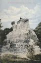
| Description: | View of the Kinnickinnic monument with two people posing on top. Caption reads: "The Wonderful Kinnickinnic Monument, Hudson, Wis." |

| Date: | 1915 |
|---|---|
| Description: | Elevated view of the St. Croix River, Northwest Railroad, bridge, and part of the town of Hudson. Caption reads: "Hudson, Wis. Bird's Eye View, showing St.... |
| Date: | 1905 |
|---|---|
| Description: | Business district on Second Street lined with horse-drawn vehicles. Caption reads: "Hudson, Wis. Second Street." |
| Date: | |
|---|---|
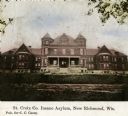
| Description: | Front of St. Croix County Insane Asylum. Clipping caption reads: "St. Croix Co. Insane Asylum, New Richmond, Wis., Pub. for C.C. Casey." |

| Date: | |
|---|---|
| Description: | Front of High School. Caption reads: "High School, New Richmond, Wis." |
| Date: | 1899 |
|---|---|
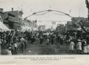
| Description: | View of a marching band parading beneath a decorated arch on Main Street. Onlookers line both sides of the street. American flags are flying over the road ... |

| Date: | |
|---|---|
| Description: | Memohead of the Glenwood Public Schools, with a three-quarter view of a school building, and names of school officials. Printed in blue ink on memo pad pap... |

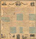
| Date: | 1876 |
|---|---|
| Description: | This 1876 map of Saint Croix County, Wisconsin, shows the township and range grid, sections, towns, cities and villages, land ownership and acreages, wagon... |
| Date: | 1886 |
|---|---|
| Description: | This 1886 map of Saint Croix County, Wisconsin, shows the township and range grid, sections, towns, cities and villages, land ownership and acreages, wagon... |

| Date: | 1890 |
|---|---|
| Description: | This late 19th century map shows mining companies' lands and miscellaneous properties in the towns of Cady and Springfield in southeastern Saint Croix Coun... |

| Date: | 1913 |
|---|---|
| Description: | This early 20th century map of Saint Croix County, Wisconsin, shows the township and range grid, sections, towns, villages, roads, railroads, and lakes and... |

| Date: | 1939 |
|---|---|
| Description: | This 1939 map of Saint Croix County, Wisconsin, shows the township and range grid, cities and villages, and lakes and streams. |
| Date: | |
|---|---|
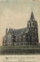
| Description: | Colorized photographic postcard view of the exterior of the Lutheran Church with arched stained glass windows. There are steps to the arched entrance below... |
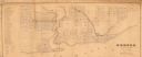
| Date: | 1850 |
|---|---|
| Description: | This map shows a plat of city, land ownership by name, local streets, roads, and part of Willow River and Lake St. Croix. The map is indexed by additions a... |
| Date: | 1855 |
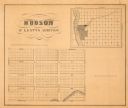
|---|---|
| Description: | This map shows McKenty's Addition between Maple Street and Hazel Street, and Spruce Street and Oak Street. The map also features an inset map of Hudson and... |

| Date: | 1973 |
|---|---|
| Description: | This map shows the uses of land in St. Croix County. Uses are indicated by colored dots. Residential(Yellow), Commercial(Red), Industrial(Grey), Parks and ... |

| Date: | 1906 |
|---|---|
| Description: | View of Second Street, a central business district. The businesses include a restaurant, a tailor, and a law office. Caption reads: "Hudson, Wis. Second St... |

| Date: | |
|---|---|
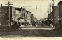
| Description: | View down unpaved Main Street, a central business district. Businesses include a pharmacy, a buffet, and a hotel. Automobiles are parked along the curbs. C... |
If you didn't find the material you searched for, our Library Reference Staff can help.
Call our reference desk at 608-264-6535 or email us at: