Filter: Categories of Wisconsin Historical Images
Filter: FORMAT_TYPE of prints, photomechanical
Filter: County of Sauk
Filter: Subject of transportation
Filter: Categories of Wisconsin Historical Images
Filter: FORMAT_TYPE of prints, photomechanical
Filter: County of Sauk
Filter: Subject of transportation

| Date: | |
|---|---|
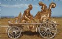
| Description: | The Peter Peter Pumpkin Eater themed circus wagon. |

| Date: | 07 1870 |
|---|---|
| Description: | This map of Ironton is pen-and-ink on paper and shows lots and block numbers, mill, foundry buildings, limestone quarry, iron mine, and roads. Relief is sh... |
| Date: | 1972 |
|---|---|
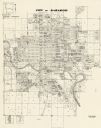
| Description: | This map shows plat of the city, city limits, local streets, and part of the Baraboo River. The map includes 3 inset maps. |

| Date: | 1975 |
|---|---|
| Description: | This map shows plat of the city, city limits, local streets, and part of Baraboo River. The map includes 2 inset maps and a legend showing residential, bus... |

| Date: | 07 1892 |
|---|---|
| Description: | Engraved illustration depicting Frank Lenz sitting on the edge of a railroad bridge holding his safety bicycle in front of him and his box camera on his ba... |

| Date: | 1910 |
|---|---|
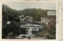
| Description: | View across water towards wooden buildings on the left and right, and a bridge over the foot of Mirror Lake. There is a woman in a rowboat on the lake in t... |
| Date: | 1908 |
|---|---|
| Description: | Photographic postcard of elevated view of the Dells of the Wisconsin River, at the foot of Mirror Lake. There is a bridge in the foreground, and a building... |
| Date: | 1910 |
|---|---|
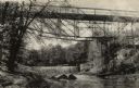
| Description: | View from shoreline looking up at the bridge, and the dam. There is a building at the base on the bridge on the opposite shoreline on the right, and anothe... |
| Date: | 1910 |
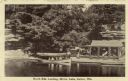
|---|---|
| Description: | View across water towards the North Side Landing. There is a covered tour boat at the edge of the lake and passengers on board. At the shoreline is a cabin... |

| Date: | 1910 |
|---|---|
| Description: | View from shoreline of boats, including an excursion boat, on the shoreline and along both sides of a pier. There are three men on the pier at Kirkland Lan... |

| Date: | 03 1964 |
|---|---|
| Description: | This map shows lot and block numbers, some landownership, disposal plant and pumping station, streets, parks, and vacated land. Lake Delton and streets are... |
| Date: | 1932 |
|---|---|
| Description: | This blue line print plat map shows local streets, numbered blocks and lots, village limits, and land ownership by name. Also included are manuscript annot... |

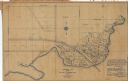
| Date: | 1861 |
|---|---|
| Description: | This map shows townships and sections, landownership, roads, railroads, rural residences, schools, churches, and topography. Also included are inset maps o... |

| Date: | 12 1903 |
|---|---|
| Description: | This manuscript blueprint map shows streets and lots and includes certifications in the left margin. Horizontal streets top to bottom are: Iroquois, Main, ... |
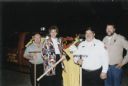
| Date: | 10 31 2001 |
|---|---|
| Description: | Group portrait with accompanying caption: "Pictured from left to right are recently retired Rock Springs Fire Department chief James "Bink" Mooney, 50th As... |

| Date: | 1940 |
|---|---|
| Description: | This pictorial map shows points of interest, recreation activities, and highways in the vicinity of the restaurant and covers the Wisconsin River Valley be... |
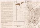
| Date: | 1999 |
|---|---|
| Description: | This map shows the best places to view bald eagles and areas to avoid when watching for eagles. The back of the map includes text and illustrations. |

| Date: | 1949 |
|---|---|
| Description: | This map shows points of interest, historic sites, buildings, trails, roads, and general animal and plant locations. |

| Date: | 1925 |
|---|---|
| Description: | Elevated view across Mirror Lake. Trees are along the steep, exposed rock faces along the shoreline. There is a boat near a boathouse on the left, and in t... |
If you didn't find the material you searched for, our Library Reference Staff can help.
Call our reference desk at 608-264-6535 or email us at: