 Filter: Categories of Wisconsin Historical Images
Filter: FORMAT_TYPE of prints, photomechanical
Filter: County of Racine
Filter: Categories of Wisconsin Historical Images
Filter: FORMAT_TYPE of prints, photomechanical
Filter: County of Racine

| Date: | 1909 |
|---|---|
| Description: | View of a camp by Bohner's Lake. Caption reads: "East Shore Bohner's Lake, Burlington." |
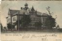
| Date: | 1905 |
|---|---|
| Description: | Hand-colored view of the exterior of a high school. A horse is grazing in the yard on the right. Caption reads: "High School, Burlington, Wis." |
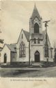
| Date: | |
|---|---|
| Description: | Exterior view of the M.E. Church. Caption reads: "1st Methodist Episcopal Church, Burlington, Wis." |

| Date: | 1958 |
|---|---|
| Description: | Elevated view of a group of worshipers at a shrine featuring a Madonna. |
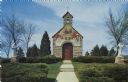
| Date: | |
|---|---|
| Description: | Color postcard view of a chapel with a fresco on the front. Statues of a Madonna and child and St. Francis are on the lawn. |
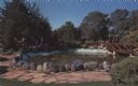
| Date: | |
|---|---|
| Description: | Color postcard view of a rock garden with a rustic bridge and koi pond. Two monks are reading on the bridge. |

| Date: | 1942 |
|---|---|
| Description: | This map of Burlington shows plat of the town, city limits, section lines, 1/4 section lines of the plat sections, roads, railroads, rivers, and lakes. The... |

| Date: | 1916 |
|---|---|
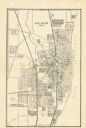
| Description: | This map of Racine includes an indexed street directory, schools, public buildings, parks, directory of buildings, and churches. The map includes 3 illustr... |

| Date: | 1921 |
|---|---|
| Description: | This map of Racine is oriented with north to the right and shows labeled streets, Lake Michigan, and points of interest. There are manuscript annotations i... |
| Date: | 1947 |
|---|---|
| Description: | This map of Racine has labeled streets, the Root River, Lake Michigan, and includes manuscript annotations of newly annexed areas and African-American neig... |

| Date: | 1956 |
|---|---|
| Description: | This map of Racine includes a street directory and index of public buildings. Streets, points of interest, Lake Michigan, and the Root River are labeled. A... |

| Date: | 1951 |
|---|---|
| Description: | This map of Racine Harbor has relief shown by contours and depths shown by gradient tints and soundings in feet. The map also shows Racine Reef, Wind Point... |
| Date: | 1950 |
|---|---|
| Description: | This map shows streets and waterways and includes annotations in red outlining wards. |
| Date: | 1872 |
|---|---|
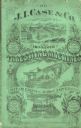
| Description: | Catalog cover reads: "J.I. Case, Manufacturers of Improved Threshing Machines, Steam Engines, Horse Powers &c." Features illustrations of vegetables, frui... |

| Date: | 1935 |
|---|---|
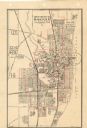
| Description: | This map includes an index on the right margin of industrial plants, churches, schools, and public buildings. Streets, the Rock River, Lake Michigan, parks... |

| Date: | 1883 |
|---|---|
| Description: | This map shows lots, neighborhood additions and subdivisions (some in blue, green, pink, and yellow), and numbered wards. Streets, Lake Michigan, and the R... |

| Date: | 1904 |
|---|---|
| Description: | This map is mounted on cloth and shows streets, railways, and city wards. A stamp in the right margin reads: "The Library of Congress, one copy received Fe... |

| Date: | 1858 |
|---|---|
| Description: | This map shows lot and block numbers, landownership, buildings, railroads, roads, wards, points of interest, parks, and cemeteries. Also included are illus... |

| Date: | 01 18 1907 |
|---|---|
| Description: | This map shows Lake Michigan, streets, schools, churches, businesses, cemeteries, parks, and railroads. Relief is shown by contours; depths are shown by so... |
If you didn't find the material you searched for, our Library Reference Staff can help.
Call our reference desk at 608-264-6535 or email us at:
