Filter: Categories of Wisconsin Historical Images
Filter: FORMAT_TYPE of prints, photomechanical
Filter: County of Milwaukee
Filter: Categories of Wisconsin Historical Images
Filter: FORMAT_TYPE of prints, photomechanical
Filter: County of Milwaukee
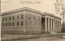
| Date: | 1910 |
|---|---|
| Description: | Exterior view of the Salzmann Library, Saint Francis, WI. Caption reads: "Salzmann Library St. Francis, Wis." |
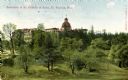
| Date: | 1920 |
|---|---|
| Description: | Exterior view of the seminary of St. Francis of Sales. Caption reads: "Seminary of St. Francis of Sales, St. Francis, Wis." |

| Date: | 1870 |
|---|---|
| Description: | Old Milwaukee County Court House and adjoining buildings as they appeared from 1836 to 1870. Scene also shows pedestrians and horse-drawn vehicles. |
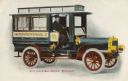
| Date: | 1909 |
|---|---|
| Description: | Milwaukee's first mail truck, here referred to as an "auto car." The date comes from a similar postcard that is postmarked. Caption reads: "Auto Car in Ma... |

| Date: | 1876 |
|---|---|
| Description: | Made from U.S. Surveys and from minutes furnished by Jos. S. Buck and Dr. C. Chase. Scale 20 CHs to an inch. |

| Date: | 1882 |
|---|---|
| Description: | This basic reference map of the state shows natural features, railroads, county seats, and political boundaries against the G.L.O. township and range grid.... |
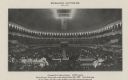
| Date: | 1909 |
|---|---|
| Description: | Interior view of the Milwaukee Auditorium during an event. |

| Date: | 1906 |
|---|---|
| Description: | Polyconic projection. Map made from surveys without spirit level control. Henry Gannett, Chief Topographer. Topography by Van H. Manning and Nat. Tyler, Jr... |

| Date: | 1908 |
|---|---|
| Description: | Colored map in perspective indicates railroad routes. Lake Winnebago and Oshkosh in center, area extends to Shawano (top right corner), Green Bay (bottom r... |
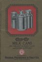
| Date: | |
|---|---|
| Description: | Catalog for the Cream City line of milk cans and other dairy supplies manufactured by Geuden, Paeschke & Frey of Milwaukee. |
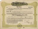
| Date: | 1917 |
|---|---|
| Description: | License from the City of Milwaukee granting Arthur Gerth permission to sell alcohol at 1222 12th Street. |
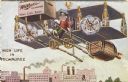
| Date: | 1911 |
|---|---|
| Description: | Humorous cartoon postcard showing a man flying an airplane constructed primarily of beer bottles, pretzels and sausages, and powered by Miller beer over th... |
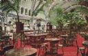
| Date: | 07 03 1886 |
|---|---|
| Description: | Hand-colored postcard of the interior of the Schlitz Palm Garden. Located on N. 3rd Street, south of W. Wisconsin Avenue, the Schlitz Palm Garden opened on... |

| Date: | |
|---|---|
| Description: | Milwaukee postcard showing a glass of beer, a pretzel, a cow and a milk maid. The card also features a short verse about Milwaukee's congeniality: "A cool ... |

| Date: | 1895 |
|---|---|
| Description: | Panoramic view of Milwaukee looking northeast. City Hall is visible at the left and Lake Michigan can be seen at the upper right. |

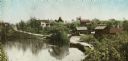
| Date: | 1853 |
|---|---|
| Description: | Plan no. 3. Scale 2000 feet to one inch. |
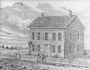
| Date: | 1836 |
|---|---|
| Description: | Drawing of the Solomon Juneau house on East Michigan. There are tethered bears on either side of the front door. Two people are leaning on the fence, watch... |
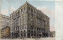
| Date: | |
|---|---|
| Description: | Exterior view across intersection toward the Pfister Hotel. Caption at right reads: "Milwaukee, Hotel Pfister." |
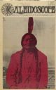
| Date: | 09 14 1970 |
|---|---|
| Description: | Cover of "Kaleidoscope," an underground newspaper, featuring a photograph of Native American Chief Sitting Bull, highlighted with red. |
If you didn't find the material you searched for, our Library Reference Staff can help.
Call our reference desk at 608-264-6535 or email us at: