Filter: Categories of Wisconsin Historical Images
Filter: FORMAT_TYPE of prints, photomechanical
Filter: County of Lincoln
Filter: Subject of water
Filter: Categories of Wisconsin Historical Images
Filter: FORMAT_TYPE of prints, photomechanical
Filter: County of Lincoln
Filter: Subject of water
| Date: | 1909 |
|---|---|
| Description: | The Lindaur Mill Flume. A man is standing in the left foreground. In the distance is the Court House with clocktower. Caption reads: "Lindaur Mill Flume, M... |
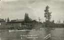
| Date: | |
|---|---|
| Description: | View from lake of the buildings of the Sunflower Cottage Resort. People are canoeing and boating in the lake in front of the resort, and a few people are s... |
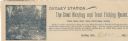
| Date: | |
|---|---|
| Description: | Letterhead of Dudley Station, a hunting and trout fishing resort in Dudley, Wisconsin. On the left is an illustration of a fisherman holding a fishing pole... |

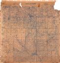
| Date: | 1915 |
|---|---|
| Description: | This 1915 map of Lincoln County, Wisconsin, shows the township and range grid, towns, cities and villages, lakes and streams, residences, churches, school ... |

| Date: | 1926 |
|---|---|
| Description: | A map of Lincoln County, Wisconsin that shows the township and range grid, towns, cities and villages, lakes and streams, residences, churches, school hous... |
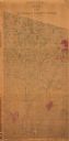
| Date: | 1872 |
|---|---|
| Description: | Shows what is currently Lincoln County and portions of Vilas, Oneida, Iron, and Langlade counties. Includes manuscript annotations of marked land tracts. |

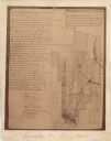
| Date: | 1887 |
|---|---|
| Description: | This map of Tomahawk shows the Wisconsin River, numbered lots, and labeled streets. The back of the map reads: "Henry C. Payne, 424 Broadway, - - Milwaukee... |
| Date: | 1930 |
|---|---|
| Description: | This map of Tomahawk shows landownership, an original plat of the city, various plat additions, roads, and railroads. The map includes annotations of road ... |
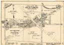
| Date: | 1943 |
|---|---|
| Description: | This map of the Village of Gleason shows land ownership by name, local streets, railroads, churches, schools, and part of Prairie River. The bottom left of... |
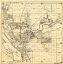
| Date: | 1900 |
|---|---|
| Description: | This map shows areas of Merrill, Corning, Scott, Rock Falls, Russel, Pelisan, Pine River, Ackley, and the Wisconsin River. The left margin of the map inclu... |

| Date: | 1982 |
|---|---|
| Description: | This standard U.S.G.S. topographic map was annotated by civil engineer and railroad historian James P. Kaysen to show the location of existing and defunct ... |

| Date: | 1902 |
|---|---|
| Description: | A plat map of Lincoln County showing Township 34 North, Range 8 East. |

| Date: | 1901 |
|---|---|
| Description: | A Sanborn map of Tomahawk featuring the Bay Mill Company's lumber yard. |

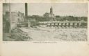
| Date: | |
|---|---|
| Description: | View along shoreline towards the stone bridge with three arches over the Prairie River. There is a stone wall along the opposite shoreline near the bridge.... |

| Date: | 1907 |
|---|---|
| Description: | Text on front reads: "Train of House Boats, at Tomahawk, Wis." A train of four houseboats in the water with another boat to pull them. Five rowboats are in... |

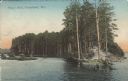
| Date: | 1904 |
|---|---|
| Description: | Text on front reads: "The Hogs Back, Tomahawk, Wis." The Hogs Back is a tree covered peninsula on Lake Mohawksin, also the former name of Bradley Park. A r... |
| Date: | 1907 |
|---|---|
| Description: | Text on front reads: "Hog's Back, Tomahawk, Wis." The Hog's Back is a tree covered peninsula on Lake Mohawksin, also the former name of Bradley Park. A man... |

| Date: | 1955 |
|---|---|
| Description: | Text on front reads: "Greetings from Tomahawk, Wisconsin." A aerial view showing the city and Lake Mohawksin on the Wisconsin River. |
If you didn't find the material you searched for, our Library Reference Staff can help.
Call our reference desk at 608-264-6535 or email us at: