 Filter: Categories of Wisconsin Historical Images
Filter: FORMAT_TYPE of prints, photomechanical
Filter: County of Lincoln
Filter: Subject of transportation
Filter: Categories of Wisconsin Historical Images
Filter: FORMAT_TYPE of prints, photomechanical
Filter: County of Lincoln
Filter: Subject of transportation
| Date: | |
|---|---|
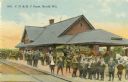
| Description: | Colorized view of a crowd at the Chicago, Milwaukee & St. Paul station. Caption reads: "C. M. & St. P. Depot Depot, Merrill, Wis." |
| Date: | 1910 |
|---|---|
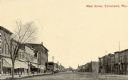
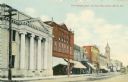
| Description: | View down center of unpaved street with storefronts on both sides. Caption reads: "Main Street, Tomahawk, Wis." |
| Date: | 1905 |
|---|---|
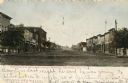
| Description: | View down center of Wisconsin Avenue, with commercial buildings and storefronts on both sides. Caption reads: "Wisconsin Ave. on a Quiet Sunday Morning, To... |

| Date: | 1905 |
|---|---|
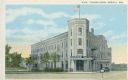
| Description: | Elevated view of the hotel on a corner. Horse-drawn vehicles are in the street. Caption reads: "Hotel Badger, Merrill, Wis." |
| Date: | 1925 |
|---|---|
| Description: | View across street towards the Badger Hotel. Caption reads: "Badger Hotel, Merrill, Wis." |
| Date: | 1910 |
|---|---|
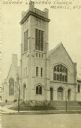
| Description: | View across street toward City Hall. Caption reads: "City Hall, Merrill, Wis." |

| Date: | 1910 |
|---|---|
| Description: | Merrill's City Hall and Library. Men are posing in front. |
| Date: | 1910 |
|---|---|
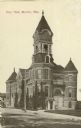
| Description: | View across street toward the church. Caption reads: "German Lutheran Church, Merrill, Wis." |
| Date: | 1910 |
|---|---|
| Description: | The First National Bank on East Main Street. In the distance is the Court House. Caption reads: "First National Bank and East Main Street, Merrill, Wis." |
| Date: | |
|---|---|
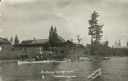
| Description: | View from lake of the buildings of the Sunflower Cottage Resort. People are canoeing and boating in the lake in front of the resort, and a few people are s... |

| Date: | 1943 |
|---|---|
| Description: | A map that shows the lands for sale by the Tomahawk Land Company of Tomahawk, Wisconsin, in the counties of Langlade, Lincoln, Oneida, and Price. The map s... |

| Date: | 1915 |
|---|---|
| Description: | This 1915 map of Lincoln County, Wisconsin, shows the township and range grid, towns, cities and villages, lakes and streams, residences, churches, school ... |

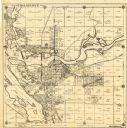
| Date: | 1926 |
|---|---|
| Description: | A map of Lincoln County, Wisconsin that shows the township and range grid, towns, cities and villages, lakes and streams, residences, churches, school hous... |

| Date: | 1887 |
|---|---|
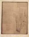
| Description: | This map of Tomahawk shows the Wisconsin River, numbered lots, and labeled streets. The back of the map reads: "Henry C. Payne, 424 Broadway, - - Milwaukee... |
| Date: | 1930 |
|---|---|
| Description: | This map of Tomahawk shows landownership, an original plat of the city, various plat additions, roads, and railroads. The map includes annotations of road ... |
| Date: | 1943 |
|---|---|
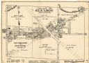
| Description: | This map of the Village of Gleason shows land ownership by name, local streets, railroads, churches, schools, and part of Prairie River. The bottom left of... |
| Date: | 1900 |
|---|---|
| Description: | This map shows areas of Merrill, Corning, Scott, Rock Falls, Russel, Pelisan, Pine River, Ackley, and the Wisconsin River. The left margin of the map inclu... |

| Date: | 1923 |
|---|---|
| Description: | This blue line print map shows townships, landownership, roads, residences, churches, schools, town halls, saw mills, and cheese factories. Includes red ma... |

| Date: | 1982 |
|---|---|
| Description: | This standard U.S.G.S. topographic map was annotated by civil engineer and railroad historian James P. Kaysen to show the location of existing and defunct ... |
If you didn't find the material you searched for, our Library Reference Staff can help.
Call our reference desk at 608-264-6535 or email us at:
