 Filter: Categories of Wisconsin Historical Images
Filter: FORMAT_TYPE of prints, photomechanical
Filter: County of Langlade
Filter: Categories of Wisconsin Historical Images
Filter: FORMAT_TYPE of prints, photomechanical
Filter: County of Langlade
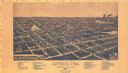
| Date: | 1886 |
|---|---|
| Description: | Bird’s-eye-view map. Map includes illustrations and index to points of interest. |

| Date: | 1926 |
|---|---|
| Description: | Map shows land ownership and streets in the town of Antigo. |

| Date: | 1950 |
|---|---|
| Description: | Aerial view of town, showing all of Lake Metonga in the background. Caption reads: "Greetings from Crandon, Wisconsin." |

| Date: | 1947 |
|---|---|
| Description: | This map shows lakes, rivers, railroads, and the soil types of Langlade County. Legends of soil types, conventional signs, and stoniness and slope are incl... |

| Date: | 1960 |
|---|---|
| Description: | This pictorial map shows recreation activities, rivers, lakes, and the history of the area. The map covers Langlade County and parts of adjacent counties. ... |
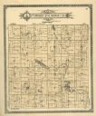
| Date: | 1913 |
|---|---|
| Description: | A plat map of the township of Norwood in Langlade County. |
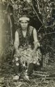
| Date: | 1908 |
|---|---|
| Description: | Photographic postcard of Qua-bas-er-o-qua, an Ojibwa (Chippewa) woman. She is seated on the ground in a low woven chair, and is wearing traditional clothin... |
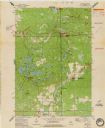
| Date: | 1973 |
|---|---|
| Description: | This standard U.S.G.S. topographic map was annotated by civil engineer and railroad historian James P. Kaysen to show the location of existing and defunct ... |

| Date: | 09 08 1960 |
|---|---|
| Description: | Text on reverse: "Greetings, White Lake, Wis. First Cast of the Day." Two fisherman, facing in opposite directions, cast their lines into the water from a ... |
If you didn't find the material you searched for, our Library Reference Staff can help.
Call our reference desk at 608-264-6535 or email us at: