 Filter: Categories of Wisconsin Historical Images
Filter: FORMAT_TYPE of prints, photomechanical
Filter: County of Lafayette
Filter: Categories of Wisconsin Historical Images
Filter: FORMAT_TYPE of prints, photomechanical
Filter: County of Lafayette
| Date: | 1871 |
|---|---|
| Description: | Darlington, county seat of Lafayette County, was established in the late 1840s, but didn't thrive until the arrival of the railroad in 1856. This view show... |

| Date: | 1881 |
|---|---|
| Description: | Darlington's first settlers arrived by 1826, attracted by the lead mines of the area. Arrival of the railroad in 1856 stimulated growth, and in 1857 the co... |

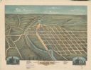
| Date: | 1896 |
|---|---|
| Description: | Bird's-eye map of Darlington. Area bordered by Washington and North Streets, upper left hand corner, the fairgrounds, upper right corner, River Street, bot... |
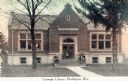
| Date: | 1914 |
|---|---|
| Description: | View toward the front of the Carnegie Library. A group of people are posing on the steps. Caption reads: "Carnegie Library, Darlington, Wis." |
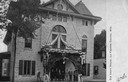
| Date: | 1900 |
|---|---|
| Description: | Front view of the Lafayette County courthouse, built in 1861. A group of people are standing at the entrance. Caption reads: "Old Court House, La Fayette C... |
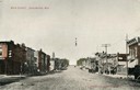
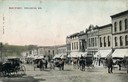
| Date: | 1905 |
|---|---|
| Description: | View down center of unpaved Main Street with storefronts on both sides. A group of people are on the sidewalk on the right. Caption reads: "Main Street, Da... |
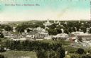
| Date: | 1905 |
|---|---|
| Description: | Caption reads: "Bird's Eye View of Darlington, Wis." |
| Date: | 1910 |
|---|---|
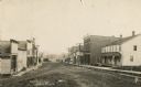
| Description: | View across unpaved street towards storefronts on the right. There are horse-drawn carriages and pedestrians moving up and down the street. Caption reads: ... |
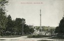
| Date: | 1905 |
|---|---|
| Description: | View down street towards Soldiers' Monument. Caption reads: "Soldiers' Monument, Darlington, Wis." |
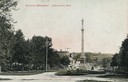
| Date: | 1907 |
|---|---|
| Description: | View down road looking towards Soldiers' Monument and town beyond. Caption reads: "Soldiers' Monument, Darlington, Wis." |

| Date: | 1910 |
|---|---|
| Description: | Elevated view of the Pecatonica River, which is curving from left to right, making two hairpin turns among fields and trees. Hills are in the distance. |
| Date: | 1900 |
|---|---|
| Description: | View down unpaved Main Street with storefronts are along both sides. A sign on a building further down on the right reads: "Nixon House". Caption reads: "S... |
| Date: | 1940 |
|---|---|
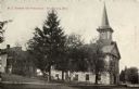
| Description: | Exterior view of the Centenary Methodist Episcopal Church and parsonage, built in 1867. Caption reads: "M.E. Church and Parsonage, Shullsburg, Wis." |

| Date: | 1836 |
|---|---|
| Description: | Lots to be sold at auction by Van Antwerp and Van Dyke on Monday, 3rd Oct. 1836. The map shows plots and labeled streets. Iowa County was later split and B... |
| Date: | 1900 |
|---|---|
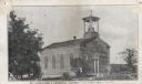
| Description: | St. Augustine's Roman Catholic Church. Built by Rev. Samuel Mazzuchelli in 1844. Caption reads: "St. Augustine's Catholic Church [text obscured]." |
| Date: | 1934 |
|---|---|
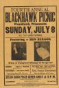
| Description: | Advertising poster for a performance by Madison magician Ben Bergor. |
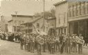
| Date: | 1906 |
|---|---|
| Description: | Brass marching band in uniforms and spectators at a Memorial Day parade. The band and spectators stand in the road outside city shops and business, includi... |

| Date: | 1866 |
|---|---|
| Description: | A map of Lafayette County, Wisconsin, showing the townships and ranges, sections, towns, villages, stream and rivers, mounds, mineral deposits and the Mine... |

| Date: | 1990 |
|---|---|
| Description: | A tourist map of Lafayette County, Wisconsin, that shows the locations of motels, camping, municipal parks, cheese factory tours, waysides, and golf course... |

| Date: | 1858 |
|---|---|
| Description: | This 1858 map shows mine shafts, lead veins, and topography on the property of the New Diggings and Shullsburg Mining Company in Section 5 of Township 1 N.... |
If you didn't find the material you searched for, our Library Reference Staff can help.
Call our reference desk at 608-264-6535 or email us at: