Filter: Categories of Wisconsin Historical Images
Filter: FORMAT_TYPE of prints, photomechanical
Filter: County of Green
Filter: Subject of architecture
Filter: Categories of Wisconsin Historical Images
Filter: FORMAT_TYPE of prints, photomechanical
Filter: County of Green
Filter: Subject of architecture

| Date: | 1871 |
|---|---|
| Description: | Birds eye map of Brodhead, WI depicts street names and street locations, houses, and trees. A reference key at the bottom of the map shows the locations of... |

| Date: | 1871 |
|---|---|
| Description: | Birds eye map of Monroe, WI, depicts street names and street locations, houses, and trees. A reference key at the bottom of the map shows the locations of ... |
| Date: | 1910 |
|---|---|
| Description: | Exterior view across street towards the Monroe Armory. Caption reads: "Armory, Monroe, Wis." |
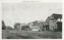
| Date: | 1945 |
|---|---|
| Description: | View across railroad tracks towards Cheese Row. Automobiles and trucks are parked near the buildings. Caption reads: "Cheese Row, Monroe, Wis." |
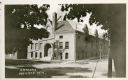
| Date: | 1950 |
|---|---|
| Description: | View across intersection towards the Green County Court House. |
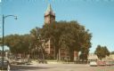
| Date: | 1950 |
|---|---|
| Description: | Elevated view of the Green County Court House. Cars are parked at an angle on the surrounding streets. |
| Date: | 1905 |
|---|---|
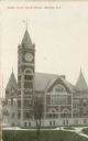
| Description: | Slightly elevated view of the courthouse. Caption reads: "Green County Court House, Monroe, Wis." |
| Date: | 1905 |
|---|---|
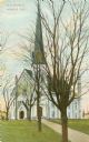
| Description: | Exterior of the Methodist Episcopal Church. Caption reads: "M.E. Church, Monroe, Wis." |

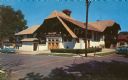
| Date: | |
|---|---|
| Description: | Exterior view towards the front and left side of the Opera House. Caption reads: "Opera House, Monroe, Wis." |

| Date: | 1950 |
|---|---|
| Description: | Exterior view of the U.S. Post Office. Caption reads: "U.S. Post Office, Monroe, Wis." |

| Date: | 1910 |
|---|---|
| Description: | View of St. John's Evangelical Church in Monroe. |
| Date: | 01 16 1911 |
|---|---|
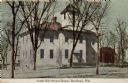
| Description: | Colorized postcard view of the South Side School House. Caption reads: "South Side School House, Brodhead, Wis." |

| Date: | |
|---|---|
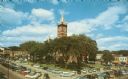
| Description: | Colorized postcard of Exchange Square on Main Street. The elevated view shows a drug store on the corner and a bank to the right. Most buildings have awnin... |

| Date: | 07 12 1909 |
|---|---|
| Description: | Colorized postcard of the Brodhead High School. A student is standing on the lawn in front, with many trees surrounding the building. Caption reads: "High ... |

| Date: | 05 18 1909 |
|---|---|
| Description: | Colorized postcard view of a Baptist Church on a street corner. Caption reads: "Baptist Church, Brodhead, Wis." |

| Date: | 1861 |
|---|---|
| Description: | Shows townships and sections, landowners, and woodlands. Includes inset maps of Monroe, Brodhead, Albany, Cadiz, Decatur, Dayton, Clarence, Springfield, Tw... |

| Date: | 1926 |
|---|---|
| Description: | A topographic map of Green County, showing by contours and spot heights the topographic and natural features of the county. The contour intervals are 20 fe... |

| Date: | 1861 |
|---|---|
| Description: | Shows townships and sections, landowners, and woodlands. Includes inset maps of Monroe, Brodhead, Albany, Cadiz, Decatur, Dayton, Clarence, Springfield, Tw... |

| Date: | 1911 |
|---|---|
| Description: | Shows roads, railroads, post offices, schools, houses, churches, and routes. Includes distant chart and explanation. "Price 35 cents"--Upper left margin. "... |
If you didn't find the material you searched for, our Library Reference Staff can help.
Call our reference desk at 608-264-6535 or email us at: