Filter: Categories of Wisconsin Historical Images
Filter: FORMAT_TYPE of prints, photomechanical
Filter: County of Grant
Filter: Categories of Wisconsin Historical Images
Filter: FORMAT_TYPE of prints, photomechanical
Filter: County of Grant
| Date: | |
|---|---|
| Description: | Color postcard of the Firehouse interior at Stonefield. The jail is through the rear door on the left. |

| Date: | |
|---|---|
| Description: | Color postcard of the classroom of the Muddy Hollow School at Stonefield. Slate tablets are on the desks. |
| Date: | |
|---|---|
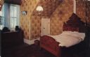
| Description: | Color postcard of the interior of the Law Office at Stonefield. A man is seated at the desk. |
| Date: | |
|---|---|
| Description: | Color postcard of a female telephone operator at an 1890s era switchboard. |

| Date: | |
|---|---|
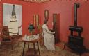
| Description: | Color postcard of the Millinery Shop at Stonefield. A woman is standing at the counter putting on a hat. Hats are displayed on the shelves behind her. |

| Date: | |
|---|---|
| Description: | Color postcard of the interior of the pharmacy, with a male druggist and two female customers. |

| Date: | |
|---|---|
| Description: | Color postcard of the Farmers' Store at Stonefield. Sales clerks, customers and merchandise set the scene. |

| Date: | |
|---|---|
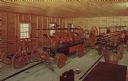
| Description: | Color postcard of the carpenter's shop at Stonefield. Carpenters are operating lathes. |

| Date: | |
|---|---|
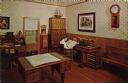
| Description: | Color postcard of the interior of the book and stationery store at Stonefield. |

| Date: | |
|---|---|
| Description: | Color postcard of the interior of the candy store at Stonefield. |

| Date: | 1971 |
|---|---|
| Description: | This map of Nelson Dewey State Park shows the park layout, points of interest, facilities, campgrounds, roads, railroads, and the Mississippi River. Relief... |

| Date: | 1850 |
|---|---|
| Description: | This map of Cassville shows plat of town, roads, and the Mississippi River. Relief is shown by hachures. The map includes an inset map of a Plat of townshi... |

| Date: | 1850 |
|---|---|
| Description: | This map of Cassville shows plat of the town, roads, landings and public wharfs and the Mississippi River. |
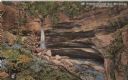
| Date: | 1914 |
|---|---|
| Description: | Postcard for Marquette Park in Grant County, number 4706 in a series by E.A. Bishop of Racine. The caption on the back of the postcard reads: "The pictures... |

| Date: | 1969 |
|---|---|
| Description: | This street map was given out by Mound City Bank and features a legend of points of interest and a street index. Streets are labeled as is the Roundtree Br... |

| Date: | 1960 |
|---|---|
| Description: | This street map was likely given out by Mound City Bank and features a legend of points of interest and a street index. Streets are labeled as is the Round... |

| Date: | 1950 |
|---|---|
| Description: | View looking down at a sundial and stone geese in a garden area with a seashell flower ring at the Dickeyville Grotto. |
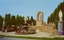
| Date: | 1950 |
|---|---|
| Description: | View of the Patriotic Shrine on the grounds of the Dickeyville Grotto. The shrine, which was created by Father Matthias Wernerus in 1929-30, honors Columbu... |

| Date: | 1929 |
|---|---|
| Description: | Interior view of the Dickeyville Grotto. Caption reads: "Inside of Grotto at Dickeyville, Wis." The following description is printed on the back of the pos... |
If you didn't find the material you searched for, our Library Reference Staff can help.
Call our reference desk at 608-264-6535 or email us at: