 Filter: Categories of Wisconsin Historical Images
Filter: FORMAT_TYPE of prints, photomechanical
Filter: County of Florence
Filter: Categories of Wisconsin Historical Images
Filter: FORMAT_TYPE of prints, photomechanical
Filter: County of Florence
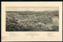
| Date: | 1881 |
|---|---|
| Description: | The county and city of Florence were named for Florence Hulst, the wife of an early settler. This view illustrates the two industries, mining and lumbering... |

| Date: | 1910 |
|---|---|
| Description: | Elevated view of Florence from across Fisher Lake, with several people standing below on the shoreline. Caption reads: "Florence, Wis. from across Fisher L... |
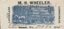
| Date: | |
|---|---|
| Description: | Letterhead of M.H. Wheeler, a lumberman from Florence, Wisconsin, with a man standing on a load of logs, holding the reins for two horses harnessed to the ... |

| Date: | 1891 |
|---|---|
| Description: | Map shows Iron and Dickinson Counties, Mich. and Florence County, Wis. "Nov. 1st, 1891." Irregularly shaped. Includes table of distances and township diagr... |

| Date: | 1907 |
|---|---|
| Description: | Shows roads, railroads, lakes, rivers, churches, and camps. |

| Date: | 1960 |
|---|---|
| Description: | This map shows uplands and swamps owned by the Goodman Lumber Division, water, and roads. The lower right corner includes a location map. The upper left co... |
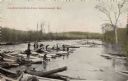
| Date: | 1909 |
|---|---|
| Description: | A group of men driving logs down the Brule. Caption reads: "Log Drive on Brule River, Near Florence, Wis." |
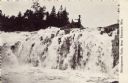
| Date: | |
|---|---|
| Description: | View of a waterfall with a man fishing from the top. Caption reads: "Michigamme Falls, Near Florence, Wis." |
If you didn't find the material you searched for, our Library Reference Staff can help.
Call our reference desk at 608-264-6535 or email us at: