 Filter: Categories of Wisconsin Historical Images
Filter: FORMAT_TYPE of prints, photomechanical
Filter: County of Dunn
Filter: Categories of Wisconsin Historical Images
Filter: FORMAT_TYPE of prints, photomechanical
Filter: County of Dunn

| Date: | 1908 |
|---|---|
| Description: | Dam on the Red Cedar River. Caption reads: "Red Cedar Dam, Menomonie, Wis." |

| Date: | |
|---|---|
| Description: | Exterior view of a stone church located at 917 7th Street. |
| Date: | 1917 |
|---|---|
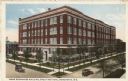
| Description: | Slightly elevated view of the Home Economics building on a street corner. Caption reads: "Home Economics Building, Stout Institute, Menomonie, Wis." |

| Date: | 1908 |
|---|---|
| Description: | The high school building. A pedestrian bridge is on the left side of the building. Caption reads: "Central School, Menomonie, Wis." |
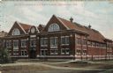
| Date: | 1907 |
|---|---|
| Description: | Exterior view of the gymnasium at Stout. Caption reads: "Stout Gymnasium and Natatorium, Menomonie, Wis." |

| Date: | |
|---|---|
| Description: | Central High School and Stout Manual Training School connected by pedestrian bridge. Two men are walking on the lawn towards the buildings. Caption reads: ... |

| Date: | |
|---|---|
| Description: | Elevated view of the Red Cedar Dam and power plants. Caption reads: "Menomonie, Wis. Bird's Eye View, Water Power and Plants." |

| Date: | 1911 |
|---|---|
| Description: | View of the gazebo and fountain at Wilson Park. Two men are sitting on a bench on the far left. Caption reads: "Wilson Park, Menomonie, Wis." |
| Date: | 1910 |
|---|---|
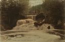
| Description: | View looking up toward a waterfall with a footbridge spanning the top. A man is on the bridge. Caption reads: "Lambs Creek Falls near Menomonie, Wis." |
| Date: | 1910 |
|---|---|
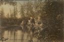
| Description: | View of Wilson Creek surrounded by pines and sandstone cliffs. Caption reads: "Wilson Creek, Menomonie, Wis." |

| Date: | |
|---|---|
| Description: | Elevated view of a railroad bridge spanning the Red Cedar River. Caption reads: "Red Cedar River Bridge, Menomonie, Wis." |
If you didn't find the material you searched for, our Library Reference Staff can help.
Call our reference desk at 608-264-6535 or email us at:
