 Filter: Categories of Wisconsin Historical Images
Filter: FORMAT_TYPE of prints, photomechanical
Filter: County of Dodge
Filter: Categories of Wisconsin Historical Images
Filter: FORMAT_TYPE of prints, photomechanical
Filter: County of Dodge

| Date: | 1960 |
|---|---|
| Description: | Colorized postcard view of bartenders and group of people at an Egyptian-themed cocktail bar, the Pyramid Supper Club, in Beaver Dam, Wisconsin. |
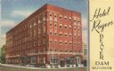
| Date: | |
|---|---|
| Description: | Colorized postcard view from street of the Hotel Rogers on a street corner. Text on front reads: "Hotel Rogers, Beaver Dam, Wisconsin." |

| Date: | |
|---|---|
| Description: | Colorized postcard view over water towards boats and boaters at a resort. In the background are people and boats near a pier. The resort is among trees on ... |
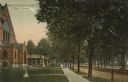
| Date: | |
|---|---|
| Description: | Colorized postcard view down the sidewalk of a tree-lined street in a residential neighborhood. Pedestrians are on the sidewalk in the front of what may be... |

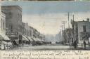
| Date: | 1909 |
|---|---|
| Description: | Colorized postcard view down the unpaved street, with the city hall building on the corner on the right. Caption reads: "City Hall and Spring Street, Beave... |
| Date: | |
|---|---|
| Description: | Colorized postcard view down center of the street in the central business district. Horses and buggies are parked along the curbs, and pedestrians are on t... |
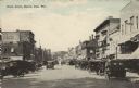
| Date: | 1921 |
|---|---|
| Description: | Colorized postcard view down the center of a busy street in the central business district. Many cars are parked at an angle along the curbs. Lampposts line... |

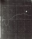
| Date: | 1932 |
|---|---|
| Description: | This map of Beaver Dam shows new boundary lines for wards, existing wards, roads, railroads, and rivers. Roads and Beaver Dam Lake are labeled. There are s... |

| Date: | 1940 |
|---|---|
| Description: | This map of Beaver Dam pictorially shows the history of the town. The map was made for the 100th anniversary celebration of Beaver Dam in 1941. The map inc... |

| Date: | 1952 |
|---|---|
| Description: | This map of Beaver Dam shows state trunk highway system, county trunk highway system, town roads, rivers, and Beaver Dam Lake and includes an additional at... |

| Date: | 1856 |
|---|---|
| Description: | This map shows a plat of the town, local streets, lots, and part of the Rock River. The margins of the map have manuscript annotations in ink. |

| Date: | 1868 |
|---|---|
| Description: | This map is ink on tracing cloth and shows lot and block numbers, depot, railroads and side tracks, and streets in sections 24 and 25, T.11, R.16E. The map... |

| Date: | 1870 |
|---|---|
| Description: | This map is ink and color on tracing cloth and shows Iron Ridge, the hotel and saw mill at Iron Ridge Village, Milwaukee & St. Paul Railway, plank road, an... |

| Date: | 11 15 1957 |
|---|---|
| Description: | This map shows single family residence district, business district, and manufacturing district, as well as block and lot numbers, Hustis Homestead, gravel ... |

| Date: | 1968 |
|---|---|
| Description: | This blue line print shows lot numbers and dimensions, existing or platted streets and highways, streets and highways to be widened, future streets, and vi... |

| Date: | 1961 |
|---|---|
| Description: | This map shows the lake, clubs, resorts, motels, school house, public approaches, and public parks. The back of map includes advertisements and text. |
| Date: | 1900 |
|---|---|
| Description: | This map shows land purchased by Solomon Juneau on Sept. 29, 1847, according to U.S. Land Office, local office tract books, Wisconsin, volume 70. Juneauvil... |

| Date: | 1891 |
|---|---|
| Description: | This map shows soft marshland, water channels, solid ground, club boundary and shooting boxes. Big Lake, First Channel, Second Channel, Fout Mile Pond, Mal... |

| Date: | 1891 |
|---|---|
| Description: | This map shows soft marshland, water channels, solid ground, club boundary and shooting boxes. Big Lake, First Channel, Second Channel, Fout Mile Pond, Mal... |

| Date: | 1900 |
|---|---|
| Description: | This map shows landownership and buildings in the community in 1876. An inset map shows Plan of Corporation of Mayville. The upper left corner includes a b... |
If you didn't find the material you searched for, our Library Reference Staff can help.
Call our reference desk at 608-264-6535 or email us at: