 Filter: Categories of Wisconsin Historical Images
Filter: FORMAT_TYPE of prints, photomechanical
Filter: County of Columbia
Filter: Categories of Wisconsin Historical Images
Filter: FORMAT_TYPE of prints, photomechanical
Filter: County of Columbia

| Date: | 1907 |
|---|---|
| Description: | View from Ludington Street of houses along a sidewalk. Trees are planted along the terrace. Caption reads: "Ludington Street, Columbus, Wis." |

| Date: | 1909 |
|---|---|
| Description: | Color-enhanced black and white photographic postcard of the Soldier's Monument in honor of the Grand Army of the Republic during the Civil War. Caption rea... |

| Date: | 1950 |
|---|---|
| Description: | Color postcard of the Farmers' and Merchants' Union Bank. The building was designed by Louis H. Sullivan and constructed in 1919 of Crawfordsville brick an... |

| Date: | 1920 |
|---|---|
| Description: | Color postcard view across street toward the high school. Caption reads: "High School, Columbus, Wis." |

| Date: | 1910 |
|---|---|
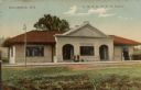
| Description: | Exterior view of the entrance to the public library. Caption reads: "Public Library, Columbus, Wis." |

| Date: | 1920 |
|---|---|
| Description: | Color postcard of the Columbus Canning Company along the river. Caption reads: "The Columbus Canning Co., Columbus, Wis." |
| Date: | 1910 |
|---|---|
| Description: | Color postcard of the Chicago, Milwaukee, St. Paul Railroad station. Five men are standing on the platform. Caption reads: "Columbus, Wis." and "C.M. & St.... |

| Date: | 1910 |
|---|---|
| Description: | Black and white photographic postcard of the Zion Evangelical Church. Caption reads: "Zion Evangelical Church, Columbus, Wis." |
| Date: | 1830 |
|---|---|
| Description: | This plat map is pen-and-ink on tracing paper and shows a paper city planned in the late 1830's located on the shore of Swan Lake, Columbia County, Wiscons... |

| Date: | 1956 |
|---|---|
| Description: | This map shows Lake Wisconsin, roads, highways, parks, resort areas, camps, gardens, and Wisconsin State experimental game and fur farm. The back of the ma... |

| Date: | |
|---|---|
| Description: | This plat map shows lots and block numbers of a paper city located on the Wisconsin River and Hasting’s Creek, in what is now the Town of West Point, Colum... |

| Date: | 1836 |
|---|---|
| Description: | This map shows lot and block numbers, streets, a proposed canal basin, Fort Winnebago, and the Wisconsin and Fox Rivers. Relief is shown by hachures and no... |

| Date: | 1855 |
|---|---|
| Description: | This map shows landownership, lot and block numbers, streets, a canal, bridges, Fort Winnebago, the Wisconsin River, and the Fox River. Relief is shown by ... |

| Date: | 11 21 1950 |
|---|---|
| Description: | This map shows agricultural, residence, business, and industrial districts as well as lot and block numbers. |

| Date: | 1960 |
|---|---|
| Description: | This map includes a sheet index showing streets, proposed streets, the high school, and railroad. |

| Date: | 1981 |
|---|---|
| Description: | Outside front cover of the 1981 State Historical Society calendar. View of hot air balloons ascending near Wisconsin Dells. |

| Date: | 1914 |
|---|---|
| Description: | This photostat map shows Fort Winnebago around 1931, land to be reserved for military purposes, roads to Fort Howard and Fort Crawford, "private property" ... |

| Date: | 1900 |
|---|---|
| Description: | This map shows landownership, churches, schools, farm houses, wagon roads, railroads, and townships and includes businesses advertisements, tables of stati... |
| Date: | 1900 |
|---|---|
| Description: | This map shows lots, public squares, landing, streets, and promenade of a paper city on a site now in the Town of West Point, Columbia County. The Wisconsi... |

| Date: | |
|---|---|
| Description: | Colorized postcard image of Colonel Chief Albert Yellowthunder of the Ho-Chunk Nation. He is wearing traditional native attire and is holding an object, wh... |
If you didn't find the material you searched for, our Library Reference Staff can help.
Call our reference desk at 608-264-6535 or email us at: