 Filter: Categories of Wisconsin Historical Images
Filter: FORMAT_TYPE of prints, photomechanical
Filter: County of Chippewa
Filter: Subject of rivers
Filter: Categories of Wisconsin Historical Images
Filter: FORMAT_TYPE of prints, photomechanical
Filter: County of Chippewa
Filter: Subject of rivers

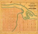
| Date: | 1886 |
|---|---|
| Description: | Bird's-eye map of Chippewa Falls, county seat of Chippewa Falls. |
| Date: | 1910 |
|---|---|
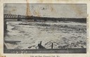
| Description: | Chippewa falls and dam. Caption reads: "Falls and Dam, Chippewa Falls, Wis." |

| Date: | 1910 |
|---|---|
| Description: | Chippewa Falls from the south side of the river below the falls. Includes the Sheely House Tavern, railway buildings, box cars, a train with five passenger... |

| Date: | 1867 |
|---|---|
| Description: | Drawn map showing planned development of Cornell, including a couple of schools, Oakwood cemetery, the public square, and several bridges and dams. |
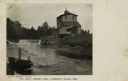
| Date: | 1913 |
|---|---|
| Description: | View from below Little Falls Dam on the Chippewa River. |

| Date: | 1872 |
|---|---|
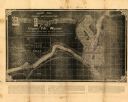
| Description: | Map of the Chippewa River, from the head of navigation at the city of Chippewa Falls, covering a distance of 16 miles above : showing the established impro... |
| Date: | 1931 |
|---|---|
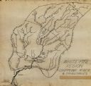
| Description: | This manuscript map shows the Chippewa River watershed, including the Red Cedar or Menomonie River, Flambeau or Manitowish River, Jump River, Eau Claire Ri... |
| Date: | 1881 |
|---|---|
| Description: | This map of Chippewa Falls is a proposal of river improvements using booming and rafting facilities and shows the city of Chippewa Falls, the Chippewa Rive... |

| Date: | 1951 |
|---|---|
| Description: | This map of Chippewa Falls shows the city of Chippewa River, city limits, roads, highways, fair grounds, and parks. |
| Date: | 1800 |
|---|---|
| Description: | This map of Chippewa Falls is a lithograph and shows plats, labeled streets, landings, some businesses, and the Chippewa River. The map was drawn "from act... |

| Date: | 1938 |
|---|---|
| Description: | This map shows plat of town, land ownership by name, city limits, section boundaries, wards, local roads, railroads, parks, fairgrounds, cemeteries, locati... |

| Date: | 1975 |
|---|---|
| Description: | This standard U.S.G.S. topographic map was annotated by civil engineer and railroad historian James P. Kaysen to show the location of existing and defunct ... |
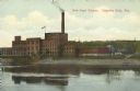
| Date: | 1910 |
|---|---|
| Description: | View across the Chippewa River towards an industrial red brick building, that is six stories tall in the center section, with a large smokestack at the cen... |
| Date: | 1920 |
|---|---|
| Description: | Colorized postcard view of Wissota hydroelectric power house and dam as seen from Lake Wissota upstream side. Wissota dam is east of Chippewa Falls. Captio... |
| Date: | 1905 |
|---|---|
| Description: | View of Tilden Mill and dam on Duncan Creek. In the foreground two men are standing and sitting on a large, flat boulder. Caption reads: "Tilden Mill, Chip... |
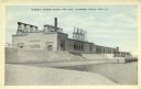
| Date: | 1909 |
|---|---|
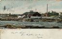
| Description: | Colorized view of Big Mill, a lumber sawmill on the Chippewa river, next to a churning rapids. In the foreground are loose logs, whitewater, river boulders... |
| Date: | 1910 |
|---|---|
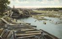
| Description: | Colorized postcard of logs floating in river, looking east between falls and railroad bridge. In the upper right corner is a large number of logging pylons... |
| Date: | 1910 |
|---|---|
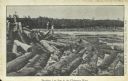
| Description: | Two men standing on logs are looking at the log jam in the river. Caption reads: "Breaking Log Jam in the Chippewa River" |
| Date: | 1910 |
|---|---|
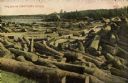
| Description: | Colorized view of log jam. A sand bluff is across the river in the upper left corner. Caption reads: "Log Jam on Chippewa River." |
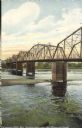
| Date: | 1910 |
|---|---|
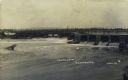
| Description: | A colorized view from shoreline of the steel beam bridge, with five sections and five bridge pylons. The bridge was downstream from the rapids on Main stre... |
If you didn't find the material you searched for, our Library Reference Staff can help.
Call our reference desk at 608-264-6535 or email us at: