 Filter: Categories of Wisconsin Historical Images
Filter: FORMAT_TYPE of prints, photomechanical
Filter: County of Brown
Filter: Year of 1800-1899
Filter: Categories of Wisconsin Historical Images
Filter: FORMAT_TYPE of prints, photomechanical
Filter: County of Brown
Filter: Year of 1800-1899

| Date: | 1876 |
|---|---|
| Description: | Elevated view showing Elmore and Kelly's Elevator with a boat, train, and the buildings at Fort Howard. Fort Howard was incorporated into Green Bay. Captio... |
| Date: | 1890 |
|---|---|
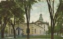
| Description: | View of the first Brown County Courthouse. Caption reads: "Court House, Green Bay, Wis." |
| Date: | 1898 |
|---|---|
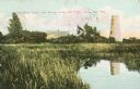
| Description: | View across field towards the lighthouse and other buildings among trees. Caption reads: "Long Tail Point, Green Bay, Wis." |
| Date: | 1898 |
|---|---|
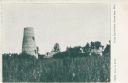
| Description: | Caption reads: "Old Stone Tower and House, Long Tail Point, Green Bay, Wis." Water and a marshy area are in the foreground. |
| Date: | 1890 |
|---|---|
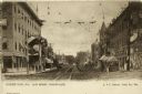
| Description: | Main Street, looking east at storefronts. Booths with flags and bunting are set up on the sidewalk. Caption reads: "Green Bay, Wis. Main Street, Looking Ea... |

| Date: | 1821 |
|---|---|
| Description: | Plan of the settlement of Green Bay. |
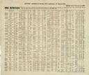
| Date: | 02 01 1864 |
|---|---|
| Description: | List of Civil War draft-dodgers issued by the Provost Marshal's office, Fifth District of Wisconsin. |

| Date: | 1896 |
|---|---|
| Description: | Portraits of the members of the Samuel Harrison Post No. 91 of De Pere, Wisconsin from 1883-1896. |
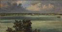
| Date: | 1856 |
|---|---|
| Description: | ". . . At De Pere they stopped on the west shore for a broad sketch of the dwellings clustered on both sides of the river. The distant dam, the mills, ware... |
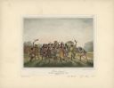
| Date: | 1842 |
|---|---|
| Description: | Menominee war dance, as depicted by Francois, Comte de Castelnau, a French naturalist and diplomat who visited Green Bay, Wisconsin about 1838. This detail... |

| Date: | 1816 |
|---|---|
| Description: | This is a photostat copy of a manuscript map in the National Archives showing a plan of Fort Howard and a view of its north side. Originally surveyed by Wi... |
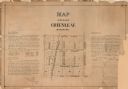
| Date: | 1873 |
|---|---|
| Description: | A plat of the village of Greenleaf, Brown County, Wisconsin, showing the areas from Taintor Street to Day Street and Follett Street to Deuster Street. Inc... |

| Date: | 1870 |
|---|---|
| Description: | This 1870 map of Brown County, Wisconsin, shows the township and range grid, towns, sections, cities, villages and post offices, land ownership, roads, rai... |

| Date: | 1896 |
|---|---|
| Description: | This map of Brown County, Wisconsin, from the late 19th century shows land claims along the Fox River, the township and range grid, towns, sections, cities... |

| Date: | 1868 |
|---|---|
| Description: | Map showing the northern water routes between Mississippi River and Atlantic Ocean Relief shown by hachures. Includes Profile of the Erie Canal, table of ... |

| Date: | 1893 |
|---|---|
| Description: | Bird’s-eye view of Depere looking North. Includes illustrations and an index to points of interest. |

| Date: | 08 27 1825 |
|---|---|
| Description: | Map is ink on paper. Map shows plat of the town of Munnomunne, the Fox River, farm lots, and an established highway. The map is signed by "J.D. Doty, Propr... |

| Date: | 1836 |
|---|---|
| Description: | This map of Navarino shows a development plat of the village situated opposite Fort Howard at mouth of the Fox River. The names of proprietors are listed a... |

| Date: | 1856 |
|---|---|
| Description: | This map shows a plat of town, local streets, and parts of East and Fox Rivers. |
If you didn't find the material you searched for, our Library Reference Staff can help.
Call our reference desk at 608-264-6535 or email us at:
