 Filter: Categories of Wisconsin Historical Images
Filter: FORMAT_TYPE of prints, photomechanical
Filter: County of Brown
Filter: Categories of Wisconsin Historical Images
Filter: FORMAT_TYPE of prints, photomechanical
Filter: County of Brown

| Date: | 1933 |
|---|---|
| Description: | Label submitted to the State of Wisconsin for trademark registration. "Pioneer Lager Beer, Bottled by De Pere Brewing Corp." The label is divided into tria... |
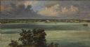
| Date: | 1856 |
|---|---|
| Description: | ". . . At De Pere they stopped on the west shore for a broad sketch of the dwellings clustered on both sides of the river. The distant dam, the mills, ware... |
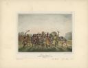
| Date: | 1842 |
|---|---|
| Description: | Menominee war dance, as depicted by Francois, Comte de Castelnau, a French naturalist and diplomat who visited Green Bay, Wisconsin about 1838. This detail... |

| Date: | 01 25 1944 |
|---|---|
| Description: | Label submitted to the State of Wisconsin for trademark registration. Label for canned food from the Larsen Company. Features a can of corn, with fresh ear... |
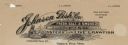
| Date: | |
|---|---|
| Description: | Memohead of the Johnson Fish Company of Green Bay, Wisconsin, wholesalers of "fresh. salt. & smoked fish, oysters and live crawfish," with a fish being pul... |

| Date: | |
|---|---|
| Description: | Letterhead of the Wm. Larsen Canning Company of Green Bay, Wisconsin, with peapods growing on the vine and three cans of peas: Larsen's Special Brand, Gree... |

| Date: | 1816 |
|---|---|
| Description: | This is a photostat copy of a manuscript map in the National Archives showing a plan of Fort Howard and a view of its north side. Originally surveyed by Wi... |

| Date: | 1914 |
|---|---|
| Description: | This map is a photostat copy from the original 1829 map in the War Department. The map shows location of Fort Howard, lots, land claims of Jacques Porlier ... |
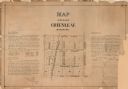
| Date: | 1873 |
|---|---|
| Description: | A plat of the village of Greenleaf, Brown County, Wisconsin, showing the areas from Taintor Street to Day Street and Follett Street to Deuster Street. Inc... |

| Date: | 1908 |
|---|---|
| Description: | This 1908 map shows the township and range grid, sections, towns, villages, railroads, bridges, lakes, streams, rapids, and state-owned lands in Oneida Cou... |

| Date: | 1959 |
|---|---|
| Description: | This map identifies public forest land and industrial forest land as of 1959 in Oneida County, Wisconsin, using a 1930 base map showing the township and ra... |

| Date: | 1930 |
|---|---|
| Description: | These 40 hand-drawn maps depict the survey townships in Oneida County, Wisconsin, on printed township grids. Lakes, rivers, and waterfront properties are d... |

| Date: | 1870 |
|---|---|
| Description: | This 1870 map of Brown County, Wisconsin, shows the township and range grid, towns, sections, cities, villages and post offices, land ownership, roads, rai... |

| Date: | 1896 |
|---|---|
| Description: | This map of Brown County, Wisconsin, from the late 19th century shows land claims along the Fox River, the township and range grid, towns, sections, cities... |
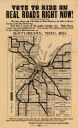
| Date: | 1919 |
|---|---|
| Description: | This flier, likely printed in 1919, promotes the vote for a bond issue to fund "hard roads" in Brown County, Wisconsin. The map shows the 135 miles of conc... |

| Date: | 1868 |
|---|---|
| Description: | Map showing the northern water routes between Mississippi River and Atlantic Ocean Relief shown by hachures. Includes Profile of the Erie Canal, table of ... |

| Date: | 1903 |
|---|---|
| Description: | Map of Brown County, Wisconsin, shows the township and range grid, towns, sections, cities, villages and post offices, land owners and acreages, railroads,... |
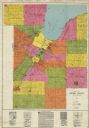
| Date: | 1930 |
|---|---|
| Description: | This early-mid 20th century map of Brown County, Wisconsin, shows the township and range grid, towns, sections, cities and villages, land owners and acreag... |

| Date: | 1961 |
|---|---|
| Description: | Map of the Town of Preble, Brown County, Wisconsin, showing land ownership by name, subdivisions, roads and streets, railroads, and local businesses. |

| Date: | 1893 |
|---|---|
| Description: | Bird’s-eye view of Depere looking North. Includes illustrations and an index to points of interest. |
If you didn't find the material you searched for, our Library Reference Staff can help.
Call our reference desk at 608-264-6535 or email us at: