 Filter: Categories of Wisconsin Historical Images
Filter: FORMAT_TYPE of prints, photomechanical
Filter: County of Brown
Filter: Categories of Wisconsin Historical Images
Filter: FORMAT_TYPE of prints, photomechanical
Filter: County of Brown
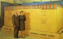
| Date: | 1965 |
|---|---|
| Description: | Colored postcard view of Mr. & Mrs. Steve Siudzinski, owners of Steve's Cheese, in front of a 34,591 pound block of cheddar cheese draped with prize winnin... |

| Date: | 1960 |
|---|---|
| Description: | Steve Siudzinski, owner of Steve's Cheese, standing in front of a vault that is holding a block of cheddar cheese weighing 13,913 lbs, and marked MFD. 1958... |
| Date: | 01 1935 |
|---|---|
| Description: | This map shows landownership and acreages, additions to Green Bay, roads, railroads, East River, and Fox River. The bottom left of the map reads: "January ... |

| Date: | 1963 |
|---|---|
| Description: | This blue line print shows as of March 1960 federal, state, county, and town roads, as well as railroads, schools, churches, town hall, parks, and Brown Co... |

| Date: | 1906 |
|---|---|
| Description: | This map shows streets, railroads, land use, public buildings, commercial businesses, and the Menominee River. Depths are shown by gradient tints and sound... |

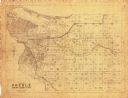
| Date: | 1888 |
|---|---|
| Description: | This is a reproduction of a map originally published in 1829 by R.W. Chandler, a pioneer settler of Galena. It is based on an earlier map by surveyor Luciu... |

| Date: | 1907 |
|---|---|
| Description: | Sanborn map of Green Bay including St. George and Main Streets. |
| Date: | 1907 |
|---|---|
| Description: | A Sanborn map of Green Bay, prominently featuring the East River. |

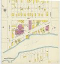
| Date: | 1907 |
|---|---|
| Description: | Sanborn map of Green Bay featuring Elm, Cedar and Main Streets. |
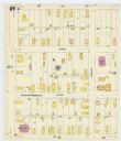
| Date: | 1907 |
|---|---|
| Description: | Sanborn map of Green Bay, including Harvey, Willow and Plesant Streets. |

| Date: | 1900 |
|---|---|
| Description: | This photostat of a manuscript map originally drawn in 1829 shows landownership, buildings, including Fort Howard and U.S. sawmill, swamps, public barns an... |

| Date: | 1900 |
|---|---|
| Description: | This photostat map shows private claim owners, natural meadows, roads, saw and grist mills, and Fort Howard. The upper right corner includes annotations an... |

| Date: | 1900 |
|---|---|
| Description: | This photostat map was probably originally created in 1835 and shows in addition to private claims, mills, roads, and trails. Green Bay and the Fox River a... |

| Date: | 1921 |
|---|---|
| Description: | This map shows various zones in a proposed city ordinance. Also shown are creeks, streets, parks, hospitals, cemeteries, and the Fox River. A legend is inc... |

| Date: | 1900 |
|---|---|
| Description: | This map shows land owners, railroads, and rivers. |

| Date: | 1965 |
|---|---|
| Description: | This map shows landownership, acreages, and roads. The city of De Pere, the town of Hobart, and the Fox River are labeled. Inset maps showing Smits Subdivi... |

| Date: | 1960 |
|---|---|
| Description: | This map is a facsimile of a 1829 map and shows private land claims, landowners within military reserve boundaries, sawmill, Fort Howard, public barns, bri... |

| Date: | 04 11 1940 |
|---|---|
| Description: | This blue line print map shows survey monument markers by type and industrial buildings and covers part of the lower Fox River and East River. The map incl... |

| Date: | 1850 |
|---|---|
| Description: | This photocopied map shows lot and block numbers, selected buildings, street names and state lock located on the Fox River. Includes a description of Deper... |
| Date: | 1917 |
|---|---|
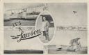
| Description: | Four views of the Lawson Military Tractor 2 (MT2). Two views are of the Lawson parked on the ground and two views show the Lawson flying in the air. In the... |
If you didn't find the material you searched for, our Library Reference Staff can help.
Call our reference desk at 608-264-6535 or email us at: