 Filter: Categories of Wisconsin Historical Images
Filter: FORMAT_TYPE of prints, photomechanical
Filter: County of Bayfield
Filter: Categories of Wisconsin Historical Images
Filter: FORMAT_TYPE of prints, photomechanical
Filter: County of Bayfield

| Date: | 1971 |
|---|---|
| Description: | A topgraphical map of Cable, Wisconsin showing railroads. |

| Date: | 1971 |
|---|---|
| Description: | A topographical map of Namekagon Lake and the surrounding area. |
| Date: | 1920 |
|---|---|
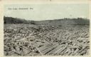
| Description: | A large open area completely filled with cut pine logs. There is a forest in the background. Caption reads: "Pine Logs, Drummond, Wis." |
| Date: | 1910 |
|---|---|
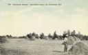
| Description: | Photographic postcard view of an open hay field with stacks of hay. The farmer in the right foreground is working on a haystack. Caption reads: "The 'Drumm... |
| Date: | 1920 |
|---|---|
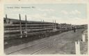
| Description: | View across snowy ground towards a steam-belching train engine on the right pulling flatbeds of stacked logs near a forest of tall pines. Caption reads: "L... |
| Date: | 1920 |
|---|---|
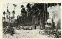
| Description: | View across railroad tracks towards train flatbeds stacked with large pine logs. There is a man standing further down the tracks looking towards the flatbe... |

| Date: | 1935 |
|---|---|
| Description: | This topographical map of the forest preserve shows highways, roads, trails, telephone lines, Native American reservations, Ranger sub-stations, state nurs... |

| Date: | |
|---|---|
| Description: | Three-quarter length portrait of Crawford Livingston Jr., a railroad man who lived in St. Paul, Minnesota. Crawford Livingston purchased the land and built... |

| Date: | |
|---|---|
| Description: | Mary Griggs Burke as a young woman, sitting outdoors at Forest Lodge smiling and holding a dachshund dog. |

| Date: | 1912 |
|---|---|
| Description: | This map shows a school reserve, swamp land, railroads, and selected buildings. |

| Date: | 1990 |
|---|---|
| Description: | This map shows various types of trails, boat landings, canoe areas, public beaches, picnic areas, campgrounds, golf courses, public tennis courts, and othe... |

| Date: | 2000 |
|---|---|
| Description: | This map shows national parks, county and state forests, Indian reservations, municipal land, private land, docks, boat access, camping, and points of inte... |

| Date: | 1929 |
|---|---|
| Description: | Aerial view of Lake Namakagon, showing the roads that connect Anderson Island (center left), and Juneks Point, Eagle Point, and Paines Island. |
| Date: | |
|---|---|
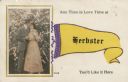
| Description: | Postcard with a hand-colored inset of a couple kissing in front of a rose bush. Text reads: "Any Time is Love Time at" A yellow banner "Herbster" "Yo... |
| Date: | |
|---|---|
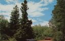
| Description: | Color reproduction of a spruce tree with an automobile parked beneath it. Text on reverse reads: "Located on the south shore of Lake Superior, near Herbs... |

| Date: | |
|---|---|
| Description: | Aerial view of the Pike Chain of Lakes near Iron River, Wisconsin. Caption reads: "Pike Chain of Lakes." Text on back reads: "The ideal vacationland for fi... |

| Date: | |
|---|---|
| Description: | Exterior view of a wooden church with a bell tower. Caption reads: "Congregational Church, Iron River, Wis." |

| Date: | |
|---|---|
| Description: | View of a wooden church with a bell tower. Caption reads: "Evangelical Church, Iron River, Wis." |

| Date: | 1904 |
|---|---|
| Description: | View overlooking Iron River in winter. Several residences, and yards with fences are in the foreground. Wooded hills are in the far background. |
If you didn't find the material you searched for, our Library Reference Staff can help.
Call our reference desk at 608-264-6535 or email us at:
