 Filter: Categories of Wisconsin Historical Images
Filter: FORMAT_TYPE of prints, photomechanical
Filter: Community of Waupaca
Filter: Categories of Wisconsin Historical Images
Filter: FORMAT_TYPE of prints, photomechanical
Filter: Community of Waupaca
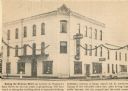
| Date: | 1964 |
|---|---|
| Description: | View of the Delavan Hotel with accompanying caption. |

| Date: | 1910 |
|---|---|
| Description: | Aerial view of some of the 26 lakes known collectively as the Chain O' Lakes. Caption reads: "Aeroplane View of Chain O'Lakes, Waupaca, Wis." |
| Date: | 1905 |
|---|---|
| Description: | Exterior view of the Waupaca courthouse. Caption reads: "Court House, Waupaca, Wis." |

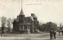
| Date: | 1896 |
|---|---|
| Description: | A map of the Chain-O-Lakes in Waupaca, including Indian trails. The path of the Waupaca Electric Railway from the Grand View Hotel to the Wisconsin Central... |
| Date: | 1976 |
|---|---|
| Description: | This is a guide to the original bikeway and additions. The front of the guide includes a map of Wisconsin, a map of the entire bikeway, and one route map. ... |

| Date: | 1941 |
|---|---|
| Description: | This pictorial map shows sites related to Indian legends, mounds, and trails in the Chain O' Lakes region in southwestern Waupaca County, Wisconsin. |

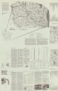
| Date: | 1898 |
|---|---|
| Description: | This 1896 map of the Chain-O-Lakes region of Waupaca County, Wisconsin, shows the lakes and streams, some topography, archaeological sites, roads, railroad... |

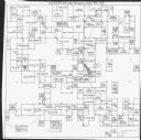
| Date: | 1898 |
|---|---|
| Description: | This 1898 map shows the contour depths of the Chain O' Lakes in Waupaca County, Wisconsin, and includes 15 cross sections of the lakes. Roads, parks, the W... |
| Date: | 1971 |
|---|---|
| Description: | This map is a photocopy of a plat created in 1966 by Malcolm Rosholt which shows the community as it appeared in 1856. The map includes land owned by Norwe... |

| Date: | 1908 |
|---|---|
| Description: | Group portrait of nine young men, in coats and hats, standing together on a sidewalk in front of the entrance to a building. Caption reads: "Junior Booster... |

| Date: | 05 26 1910 |
|---|---|
| Description: | Text on front reads: "Court House Square, Waupaca, Wis." The courthouse was built in 1882 of brick in the Neoclassical style. It was razed in in the early ... |

| Date: | 01 12 1910 |
|---|---|
| Description: | Text on front reads: "Fall Mill St., Waupaca, Wis." Water flowing over a dam on the Waupaca River. There are advertising signs on the dam and buildings ca... |
If you didn't find the material you searched for, our Library Reference Staff can help.
Call our reference desk at 608-264-6535 or email us at:
