 Filter: Categories of Wisconsin Historical Images
Filter: FORMAT_TYPE of prints, photomechanical
Filter: Community of Superior
Filter: Subject of water
Filter: Categories of Wisconsin Historical Images
Filter: FORMAT_TYPE of prints, photomechanical
Filter: Community of Superior
Filter: Subject of water

| Date: | 1883 |
|---|---|
| Description: | Bird's-eye map of Superior, county seat of Douglas County, on the shores of Lake Superior, with insets of points of interest. |

| Date: | 1913 |
|---|---|
| Description: | Bird's-eye map of Superior. "The New Steel Center." |

| Date: | 1915 |
|---|---|
| Description: | Bird's-eye view of Superior, Wisconsin, and Duluth, Minnesota on opposite shore of Lake Superior. |

| Date: | 1887 |
|---|---|
| Description: | Bird's-eye view of Superior, on Lake Superior. |

| Date: | 1890 |
|---|---|
| Description: | Bird's-eye map of West Superior and Superior, with insets of Wright Farm and First Building in Superior. |

| Date: | 1893 |
|---|---|
| Description: | Bird's-eye map of Superior. Looking from the point, with Superior Bay on left, St. Louis Bay on right, below St. Louis River. |

| Date: | 1913 |
|---|---|
| Description: | Aerial bridge and harbor, with a large boat passing underneath. A lamppost and a beacon are along the walkway towards the bridge on the left. Caption reads... |

| Date: | 01 04 1862 |
|---|---|
| Description: | Engraving of the city of Superior and Lake Superior, also depicting railroad piers, Minnesota Point, and the steamboat "Star". The engraving appears on a l... |

| Date: | 1900 |
|---|---|
| Description: | Elevated view of Tower Avenue. Caption reads: "Tower Avenue, Superior, Wis." |

| Date: | 1920 |
|---|---|
| Description: | Elevated view of the harbor. Caption reads: "The Harbor, Superior, Wis." |

| Date: | 1930 |
|---|---|
| Description: | Caption reads: "'The Old Standby' First Lighthouse Built at the Head of Lake Superior—Superior Entry — 1854 Keepers, Com. Saxton and Samuel Palmer." |

| Date: | 1915 |
|---|---|
| Description: | Elevated view of the harbor. Caption reads: "The Harbor, Superior, Wis." |

| Date: | 1910 |
|---|---|
| Description: | Caption reads: "The Great Northern. One of the largest Elevators in the World, Superior, Wis." |

| Date: | 1960 |
|---|---|
| Description: | Aerial view with docks in the foreground. Caption reads: "Superior, Wisconsin." |
| Date: | |
|---|---|
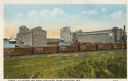
| Description: | Cargill Elevators and Great Northern Yards. Caption reads: "Cargill Elevators and Great Northern Yards, Superior, Wis." |
| Date: | |
|---|---|
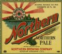
| Description: | Label for Northern Pale brewed by Northern Brewing Company. The label depicts a lake scene with evergreen trees in the background and the round Northern Be... |

| Date: | 1911 |
|---|---|
| Description: | This map, taken from the 1911 Map of Wisconsin showing geology and roads by Hotchkiss and Thwaites, shows the northwest portion of Douglas County, Wisconsi... |

| Date: | 1890 |
|---|---|
| Description: | This map of Superior shows city wards, bays, docks, some businesses and points of interest. Relief is shown by hachures. The back of the map features a typ... |

| Date: | 1898 |
|---|---|
| Description: | This map of Superior shows city wards, bays, docks, and some businesses and points of interest. Relief is shown by hachures. The map probably came from a C... |

| Date: | 1898 |
|---|---|
| Description: | This map of Duluth and Superior show lands that "will be for sale soon" in portions of Douglas County, Wisconsin and Saint Louis County, Minnesota. The map... |
If you didn't find the material you searched for, our Library Reference Staff can help.
Call our reference desk at 608-264-6535 or email us at: