Filter: Categories of Wisconsin Historical Images
Filter: FORMAT_TYPE of prints, photomechanical
Filter: Community of Sparta
Filter: Categories of Wisconsin Historical Images
Filter: FORMAT_TYPE of prints, photomechanical
Filter: Community of Sparta
| Date: | 1900 |
|---|---|
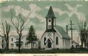
| Description: | Colorized view of the church. Caption reads: "Zion's Church, Sparta, Wis." |
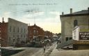
| Date: | 1910 |
|---|---|
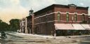
| Description: | View of Water Street, featuring the Monroe County Bank on the corner on the left. Caption reads: "Water Street, Looking North, Sparta, Wis." |
| Date: | 1905 |
|---|---|
| Description: | Elevated view over rooftops towards a main street during berry season. Horse-drawn wagons are gathered further down the street near an intersection. The Mo... |
| Date: | 1920 |
|---|---|
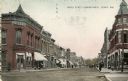
| Description: | View down street towards an intersection. Large lampposts are at each corner. A sign on the building on the left reads: "Sidney." Caption reads: "Oak St. E... |
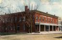
| Date: | 1900 |
|---|---|
| Description: | Diagonal view across road toward the hotel. Caption reads: "Hotel Lewis, Sparta, Wis." |
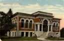
| Date: | 1920 |
|---|---|
| Description: | View toward the front of the library. Caption reads: "Carnegie Library, Sparta, Wis." |
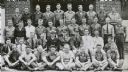
| Date: | 1937 |
|---|---|
| Description: | A group portrait of the Motor Transportation and Utilities Department of the Sparta District CCC. Jacob Spreuer, junior dispatcher, is in the second row. |

| Date: | 1940 |
|---|---|
| Description: | This maps shows the areas in Monroe, Jackson, and Juneau counties, Wisconsin, where U.S. Army maneuvers were held in August 1940. Highways and roads, commu... |
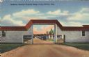
| Date: | |
|---|---|
| Description: | Colorized postcard view of an arch at Camp McCoy with ramps on either side and a road passing through it. Parked cars and barracks are on the far side of t... |

| Date: | |
|---|---|
| Description: | Large Letter style postcard with representative images in the letters of "Camp Mc-Coy", including tents, artillery, barracks and soldiers. Caption reads: "... |

| Date: | |
|---|---|
| Description: | Colorized view of the Officer's Club at Camp McCoy. There is an officer standing at the entrance. Caption reads: "Officer's Club, Camp McCoy, Wis." |

| Date: | 1909 |
|---|---|
| Description: | This is one of a set of two topographical maps showing land use, roads, railroads, bridges, and buildings with ownership in parts of LaFayette, Greenfield,... |

| Date: | 1909 |
|---|---|
| Description: | This the second of a set of two topographical maps showing land use, roads, railroads, bridges, and buildings with ownership in parts of LaFayette, Greenfi... |
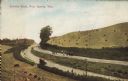
| Date: | 1907 |
|---|---|
| Description: | Text on front reads: "County Road, Near Sparta, Wis." Elevated view of a group of people standing on an unpaved county road that runs through a cut in a hi... |
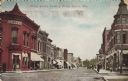
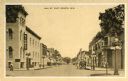
| Date: | 08 09 1911 |
|---|---|
| Description: | Text on front reads: "Water Street, Looking North, Sparta, Wis." Unpaved street with sidewalks lined with businesses. Signs read, "Monroe County Bank," "Dr... |

| Date: | 1942 |
|---|---|
| Description: | Text on front reads: "Hotel Sydney - Sparta, Wis. European - Modern - Dining Room." View from intersection of a two-story hotel with three-story towers on ... |

| Date: | 1904 |
|---|---|
| Description: | Text on front reads: "Castle Rock near Sparta, Wis." A formation about 600 feet high, having on its summit a large circular rock, named Castle Rock, for it... |
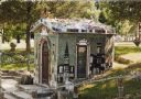
| Date: | 1987 |
|---|---|
| Description: | Text on reverse reads: "Paul & Matilda Wegner Grotto. Little Glass Church ca 1930-1934. Located on Highway 71, 1/4 mile west of Hwy. 27, 9 miles north of S... |
If you didn't find the material you searched for, our Library Reference Staff can help.
Call our reference desk at 608-264-6535 or email us at: