 Filter: Categories of Wisconsin Historical Images
Filter: FORMAT_TYPE of prints, photomechanical
Filter: Community of Platteville
Filter: Categories of Wisconsin Historical Images
Filter: FORMAT_TYPE of prints, photomechanical
Filter: Community of Platteville

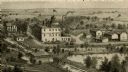
| Date: | 1875 |
|---|---|
| Description: | Bird's-eye map of Platteville. |
| Date: | |
|---|---|
| Description: | An engraving based on a drawing by Alexander Simplot of the Platteville Brewery (spelled Plattville). It is an elevated perspective showing the main buildi... |
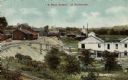
| Date: | 1915 |
|---|---|
| Description: | Elevated view of mining operations. Caption reads: "'A Busy Corner' of Platteville." |

| Date: | 1920 |
|---|---|
| Description: | Exterior view of the Post Office. Caption reads: "Post Office, Platteville, Wis." |
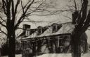
| Date: | 1945 |
|---|---|
| Description: | A view of the Mitchell-Rountree house. Built in 1837 for the Rev. Samueal Mitchell under the direction of his daughter's husband, Major John H. roundtree, ... |
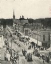
| Date: | 1907 |
|---|---|
| Description: | Elevated view of Main Street. Crowds line the sidewalks, and horse drawn vehicles and people are moving down the street. |

| Date: | 1911 |
|---|---|
| Description: | Caption reads: "Main Street, looking East, Platteville,,[sic] Wis." |
| Date: | 1905 |
|---|---|
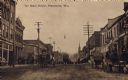
| Description: | View looking down center of Main Street, with horse-drawn vehicles. Caption reads: "On Main Street, Platteville, Wis." |

| Date: | 1915 |
|---|---|
| Description: | A view of City Hall, erected in 1883. Caption reads: "City Hall, Platteville, Wis." |
| Date: | |
|---|---|
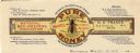
| Description: | Letterhead of N.E. France of Platteville, Wisconsin, the general manager and treasurer of the National Bee-Keepers Association, in the form of a label for... |
| Date: | |
|---|---|
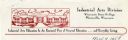
| Description: | Letterhead of the Industrial Arts Division, Wisconsin State College-Platteville, with a view of the front of the division building and a cloud-filled sky, ... |

| Date: | 1969 |
|---|---|
| Description: | This street map was given out by Mound City Bank and features a legend of points of interest and a street index. Streets are labeled as is the Roundtree Br... |

| Date: | 1960 |
|---|---|
| Description: | This street map was likely given out by Mound City Bank and features a legend of points of interest and a street index. Streets are labeled as is the Round... |

| Date: | 1906 |
|---|---|
| Description: | This topographical map shows the Little Platte River, shafts, test-pits, old workings, contour lines of Galena limestone elevation, railroads, and building... |

| Date: | 1900 |
|---|---|
| Description: | This photocopy map shows labeled streets and plats. |
If you didn't find the material you searched for, our Library Reference Staff can help.
Call our reference desk at 608-264-6535 or email us at: