 Filter: Categories of Wisconsin Historical Images
Filter: FORMAT_TYPE of prints, photomechanical
Filter: Community of Madison
Filter: Categories of Wisconsin Historical Images
Filter: FORMAT_TYPE of prints, photomechanical
Filter: Community of Madison

| Date: | 1906 |
|---|---|
| Description: | View of Lake Mendota Drive at the foot of Stevens Hill. |
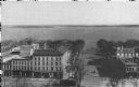
| Date: | 1914 |
|---|---|
| Description: | Monona Avenue with Lake Monona in the background. (Martin Luther King, Jr. Boulevard as of January 19, 1987). View from the dome of the Wisconsin State Cap... |
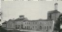
| Date: | 1899 |
|---|---|
| Description: | Exterior view of the Hausmann Brewing Company's Malt House, 1603 Sherman Avenue. |

| Date: | 1920 |
|---|---|
| Description: | A map of Madison and the vicinity. Red lines show the street railway. |

| Date: | 1904 |
|---|---|
| Description: | This map shows a plat of the east part of the city, numbered blocks and lots, some landownership, local streets, roads, railroads, wards by number, parks, ... |

| Date: | 1920 |
|---|---|
| Description: | Map of the Nakoma neighborhood including the proposed golf grounds. |

| Date: | 1856 |
|---|---|
| Description: | Isthmus of Madison, including Lake Mendota, or Great Lake, and Lake Menona [sic]. |
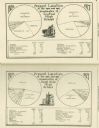
| Date: | 1927 |
|---|---|
| Description: | Pie charts from 1927-28 showing the present location of graduates of Central and East High Schools. |

| Date: | 1890 |
|---|---|
| Description: | Portion of a plat map of Madison featuring Lake Mendota. |

| Date: | 1890 |
|---|---|
| Description: | Left half of a plat map of the "East Part of the city of Madison". |

| Date: | 1890 |
|---|---|
| Description: | Right side of a plat map of the "East Part of the City of Madison". |

| Date: | 1890 |
|---|---|
| Description: | Portion of a plat map of the "West Part of the City of Madison". |

| Date: | 1904 |
|---|---|
| Description: | This map shows a plat of the west part of the city, numbered blocks and lots, some landownership, local streets, roads, railroads, wards by number, parks, ... |
| Date: | 1872 |
|---|---|
| Description: | A lithograph of the layout of Hooley's Opera House. |
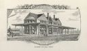
| Date: | 1887 |
|---|---|
| Description: | View across railroad tracks towards the Illinois Central railway station. A horse-drawn vehicle is on the left, and people are along the platform. Caption ... |

| Date: | 1917 |
|---|---|
| Description: | Colorized view of King Street as seen from the Capitol grounds. Caption reads: "Looking Toward King Street from the Capitol, Madison, Wis." |

| Date: | 1917 |
|---|---|
| Description: | Colorized view of King Street as seen from the Capitol grounds. Caption reads: "View from New State Capitol, looking East, Madison, Wis." |
If you didn't find the material you searched for, our Library Reference Staff can help.
Call our reference desk at 608-264-6535 or email us at:


