 Filter: Categories of Wisconsin Historical Images
Filter: FORMAT_TYPE of prints, photomechanical
Filter: Community of Cornell
Filter: Categories of Wisconsin Historical Images
Filter: FORMAT_TYPE of prints, photomechanical
Filter: Community of Cornell

| Date: | 1867 |
|---|---|
| Description: | Drawn map showing planned development of Cornell, including a couple of schools, Oakwood cemetery, the public square, and several bridges and dams. |
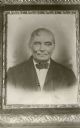
| Date: | |
|---|---|
| Description: | Crayon portrait of Jean Brunet who kept a lumberman's stopping place at Brunette Falls (now Cornell), on the Chippewa River. |

| Date: | 1912 |
|---|---|
| Description: | This blueprint manuscript map shows landownership, mills, railroad, churches, public buildings, the old cemetery, and the Chippewa River and Reservoir. The... |
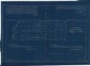
| Date: | 11 1925 |
|---|---|
| Description: | This blueprint manuscript map shows an addition. The map was surveyed and platted for B.G. Proctor, president, and George Peterson, secretary, of the Corne... |
If you didn't find the material you searched for, our Library Reference Staff can help.
Call our reference desk at 608-264-6535 or email us at: