 Filter: Categories of Wisconsin Historical Images
Filter: FORMAT_TYPE of prints, photomechanical
Filter: Creator Name of Unknown
Filter: Year of 1700-1799
Filter: Categories of Wisconsin Historical Images
Filter: FORMAT_TYPE of prints, photomechanical
Filter: Creator Name of Unknown
Filter: Year of 1700-1799

| Date: | 1761 |
|---|---|
| Description: | A plan of the Straits of St. Mary and Michilimakinac, to shew the situation and importance of the two westernmost settlements of Canada for the fur trade. ... |

| Date: | 1784 |
|---|---|
| Description: | Map of The United States of America according to the Treaty of Peace of 1784. |
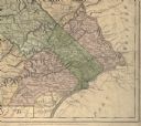
| Date: | 1775 |
|---|---|
| Description: | Detail of Pennsylvania map showing Chester, Philadelphia, and Bucks counties. |

| Date: | 1720 |
|---|---|
| Description: | Map showing the course of the Mississippi River from the Gulf of Mexico up past Lake Superior into Canada. It shows the towns, Native American tribes and l... |

| Date: | 1755 |
|---|---|
| Description: | Map of the Great Lakes region during the French and Indian War. It shows in great detail the territories, borders and boundary lines, Native American tribe... |
If you didn't find the material you searched for, our Library Reference Staff can help.
Call our reference desk at 608-264-6535 or email us at: