 Filter: Categories of Wisconsin Historical Images
Filter: FORMAT_TYPE of prints, fine-art
Filter: Subject of transportation
Filter: Categories of Wisconsin Historical Images
Filter: FORMAT_TYPE of prints, fine-art
Filter: Subject of transportation
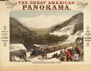
| Date: | 1900 |
|---|---|
| Description: | An original colored lithograph advertising the Pacific Railway's route from New York to California, encouraging people to "Go and See the Great American Pa... |
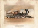
| Date: | 1900 |
|---|---|
| Description: | An original color lithograph featuring a side profile of "The Famous War Engine "General" of the Western & Atlantic R. R." The artist depicts the steam eng... |
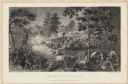
| Date: | 07 21 1861 |
|---|---|
| Description: | Depiction of the battlefield. Engraved by J.C. McRae and drawn by W. Momberger. |

| Date: | |
|---|---|
| Description: | A large lithograph of the most immediate of the tragic results of the civil war in Mobile, Alabama, which was the great explosion of May 25, 1865. Federal ... |
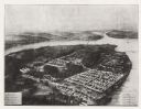
| Date: | 1864 |
|---|---|
| Description: | Aerial view, probably from a lithograph, of the prison for Confederate soldiers at Rock Island. |
| Date: | 1863 |
|---|---|
| Description: | Woodcut of Andersonville Prison from the "Report of the Andersonville Monument Commission." About 1863-1865. |
| Date: | 1864 |
|---|---|
| Description: | "Andersonville Prison, Camp Sumter, Ga., as it appeared August 1st 1864 when it contained 35,000 prisoners of war." |

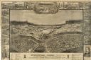
| Date: | 1695 |
|---|---|
| Description: | Copperplate engraving; Venice, 1695. Scale [ca. 1:5,069,000] at center. |

| Date: | 1688 |
|---|---|
| Description: | This map includes vignettes of Amerindian life with text describing geography, culture, and exploration activity, written in French. The Great Lakes, river... |

| Date: | 1778 |
|---|---|
| Description: | Hand-colored. London, 1778. Coordinates: W 99⁰--W 83⁰/N 49⁰--N 41⁰. Scale [ca. 1:3,500,000] |

| Date: | 1934 |
|---|---|
| Description: | Poster for an anti-war documentary film written by Burnet Hershey and produced by M.J. Kandel for Ideal Pictures Corp. |
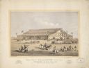
| Date: | 1869 |
|---|---|
| Description: | A lithograph of the Coliseum for the Grand National Peace Jubilee in Boston, Massachusetts on June 15-19. |
| Date: | |
|---|---|
| Description: | Commemorative poster honoring duties of the States and those that fought and lead the war. |
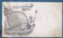
| Date: | 1860 |
|---|---|
| Description: | A Union sailor and King Neptune stand inside a sea shell that is floating on the ocean. Between them appears a decorative circle with the Union Armada in i... |
| Date: | 1860 |
|---|---|
| Description: | A cherub (angel) sits on a wagon with a bellows on top. He is blowing bubbles from a pipe. The newest bubble has the words " A ZEPHYR" in it (a zephyr is a... |
| Date: | 1860 |
|---|---|
| Description: | A circus traveling on the road has three cages, the first and second are flying the Confederate flag. A stone at the side of the road says "TO BOSTON." "T... |
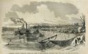
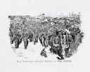
| Date: | 05 31 1862 |
|---|---|
| Description: | Engraved view of the Commisary [sic] depot of Major-General Halleck's army at Hamburg Landing. |

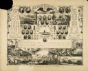
| Date: | 1875 |
|---|---|
| Description: | The International Order of the Odd Fellows (I.O.O.F.) serve their fellow man by following the tenets of Friendship, Love, and Truth. A secret society for t... |
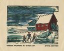
| Date: | 1949 |
|---|---|
| Description: | Holiday card of the Sister Bay lakeshore. Three figures are on the shore. Two boathouses, a covered boat, a pier, and two upright boats are in the backgrou... |

| Date: | 1865 |
|---|---|
| Description: | This pen and ink map sketches the route taken by General Sherman's troops from Atlanta, Georgia, to Savannah, Georgia. Railroads, rivers, and towns are lab... |
If you didn't find the material you searched for, our Library Reference Staff can help.
Call our reference desk at 608-264-6535 or email us at: