 Filter: Categories of Wisconsin Historical Images
Filter: FORMAT_TYPE of prints, fine-art
Filter: Subject of rivers
Filter: Year of 1900-1999
Filter: Categories of Wisconsin Historical Images
Filter: FORMAT_TYPE of prints, fine-art
Filter: Subject of rivers
Filter: Year of 1900-1999
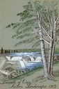
| Date: | 1973 |
|---|---|
| Description: | Cover for the Wisconsin Friends of Our Native Landscape program. Depicted is a river cascading over rocks, and some trees in the foreground. The Wisconsin ... |

| Date: | 1910 |
|---|---|
| Description: | The original caption reads: "The Kalispel, who now number about a hundred, are scattered along the eastern side of the Pend d'Oreille river in eastern Wash... |

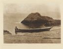
| Date: | 1910 |
|---|---|
| Description: | The original caption reads: "Spokane river, from a short distance below its head in Coeur d'Alene lake to its confluence with the Columbia, flows through t... |
| Date: | 1910 |
|---|---|
| Description: | The original caption reads: "The Chinookan tribes on the Columbia obtained their canoes for the greater part from the coast tribes of Washington. The woman... |
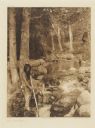
| Date: | 1923 |
|---|---|
| Description: | The original caption reads: "A Hupa youth is waiting with poised spear for the shadowy outline of a salmon lurking in a quiet pool and gathering its streng... |
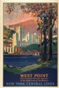
| Date: | 1928 |
|---|---|
| Description: | An original lithograph promoting New York Central Lines railway and the West Point military academy, in a location described as being "In the highlands of ... |
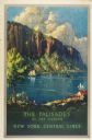
| Date: | 1947 |
|---|---|
| Description: | An original lithograph promoting "The Palisades of the Hudson," via the New York Central lines train system. The poster depicts a dramatic cliff overlookin... |
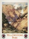
| Date: | 1924 |
|---|---|
| Description: | An original lithograph promoting the Grand Canyon of Yellowstone Park, and to get there by way of the Northern Pacific Railway. The poster depicts a dramat... |

| Date: | 1925 |
|---|---|
| Description: | An original colored lithograph advertising the London Transport system, and promoting travel to "Kingston by Tram." The poster features the artist Frank N... |

| Date: | 1900 |
|---|---|
| Description: | A map of La Crosse County, Wisconsin, showing and identifying the townships and section numbers, towns, cities and villages, landowners, rivers, railroads,... |

| Date: | 1930 |
|---|---|
| Description: | Lower left hand corner reads: "Compliment of the Madison Association of Commerce MADISON The Four Lake City WISCONSIN." Around the perimeter of the map is ... |

| Date: | 1954 |
|---|---|
| Description: | This map of Waukesha shows numbered ward boundaries, roads, and some buildings. The bottom of the map includes a street index. |

| Date: | 1950 |
|---|---|
| Description: | This map of Racine's business section is oriented with the north to the right and shows businesses and lot owners. Businesses, streets, and the Root River ... |
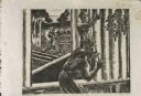
| Date: | 1937 |
|---|---|
| Description: | Linoleum cut engraved view of men building a log cabin. One man carries a log in the background near a lake or river, while another man nails a log held in... |

| Date: | 1945 |
|---|---|
| Description: | This maps shows roads, railroads, parks, recreational areas, Lake Wingra, Lake Monona, and part of Lake Mendota. The map includes pictorial images that dep... |

| Date: | 1975 |
|---|---|
| Description: | This map provides an index of outdated quadrangle maps for the state. Communities, counties, rivers, and lakes are labeled including Lake Michigan and Lake... |

| Date: | 1937 |
|---|---|
| Description: | Pictorial map showing historical events and locations within the state of Wisconsin, as well as waterways and counties. Original caption on the bottom marg... |

| Date: | 1947 |
|---|---|
| Description: | This map shows territorial roads laid out and opened between 1836 to 1848. Includes a scale in miles. Routes are labeled by numbers and indicated in key on... |

| Date: | 1938 |
|---|---|
| Description: | This map shows roads, parks, golf courses, airports, beaches, docks and harbors, lighthouses, and buoys within Winnebago County and parts of Waushara, Calu... |

| Date: | 1950 |
|---|---|
| Description: | This map shows regions in Northern Illinois and Southern Wisconsin roughly bounded by Lake Winnebago, the Kankakee River, Peoria, and Prairie du Chien. The... |
If you didn't find the material you searched for, our Library Reference Staff can help.
Call our reference desk at 608-264-6535 or email us at: