 Filter: Categories of Wisconsin Historical Images
Filter: FORMAT_TYPE of prints, fine-art
Filter: Subject of postal service
Filter: Categories of Wisconsin Historical Images
Filter: FORMAT_TYPE of prints, fine-art
Filter: Subject of postal service
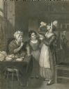
| Date: | 1850 |
|---|---|
| Description: | Two post office employees look on as a third looks into an envelope. |

| Date: | 1950 |
|---|---|
| Description: | An original lithograph promoting the United Airlines as both a passenger airplane and an Air Mail airplane. The poster states, "This new United Air Lines "... |
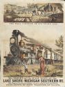
| Date: | 1875 |
|---|---|
| Description: | Colored print containing two images advertising the delivery of mail. The main image is of the large Michigan and Southern train labeled "The Fast Mail" de... |

| Date: | 1871 |
|---|---|
| Description: | Map created between 1871 and 1880. Shows townships, post offices, a possible railroad to Penoka Iron Range, and the North Wisconsin Railroad. |
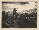
| Date: | |
|---|---|
| Description: | Engraved print depicting two people harvesting grain along a fence line in a field. One person holds a scythe while the other carries a bucket, possibly th... |

| Date: | 1857 |
|---|---|
| Description: | This map shows the railroad routes of the Milwaukee & Horicon Railroad, common roads, counties, canals, townships, cities, county towns, villages, post off... |

| Date: | 1900 |
|---|---|
| Description: | This map shows landownership, railroads, roads, churches, schools, cemeteries, post offices, townships, city wards, Lake Michigan, and rivers. The map incl... |

| Date: | 1902 |
|---|---|
| Description: | This map shows townships, land parcels, schools, rivers, lakes, creameries, churches, cemeteries, roads, post offices, town halls, saw mills, roads and sto... |

| Date: | 1915 |
|---|---|
| Description: | This map shows roads, railroads, street railways, abandoned logging railroads, rural mail routes, telephone lines, schools, platted land, and state forest ... |

| Date: | 1720 |
|---|---|
| Description: | One of Herman Moll's most famous maps, often referred to as The Beaver Map for its elaborate engraved inset depicting and describing beavers building a dam... |

| Date: | 1871 |
|---|---|
| Description: | This maps shows the entire state with an inset map in the lower left corner of Milwaukee. Railroads, roads, canals, the state capital, towns, cities, towns... |

| Date: | 1767 |
|---|---|
| Description: | Map of the north east coast of America, showing colonial borders, cities, Native American land, lakes, rivers, and a few hills and mountains. Illustrated t... |

| Date: | 1780 |
|---|---|
| Description: | Detailed map of America east of the Louisiana region. It shows forts, cities, borders and boundary lines, Native American land, the post road, mountains, w... |
If you didn't find the material you searched for, our Library Reference Staff can help.
Call our reference desk at 608-264-6535 or email us at: