 Filter: Categories of Wisconsin Historical Images
Filter: FORMAT_TYPE of prints, fine-art
Filter: Subject of persons
Filter: Type of Map or Atlas
Filter: Year of 1900-1999
Filter: Categories of Wisconsin Historical Images
Filter: FORMAT_TYPE of prints, fine-art
Filter: Subject of persons
Filter: Type of Map or Atlas
Filter: Year of 1900-1999
| Date: | 1949 |
|---|---|
| Description: | This map of the Beloit College Campus is a pictorial depiction of the layout of campus including buildings and students depicted as Shmoos (popular cartoon... |

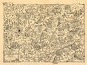
| Date: | 1937 |
|---|---|
| Description: | Pictorial map showing historical events and locations within the state of Wisconsin, as well as waterways and counties. Original caption on the bottom marg... |
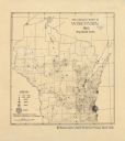
| Date: | 1905 |
|---|---|
| Description: | This map shows the German-born population in the state of Wisconsin. County boundaries are visible. In the lower left margin it includes a legend showing t... |

| Date: | 1929 |
|---|---|
| Description: | This map with north oriented to the upper left shows military forts, Indian villages, settler's houses with surnames, trading houses, lodges and encampment... |

| Date: | 1982 |
|---|---|
| Description: | This map shows the location of major settlement regions for various ethnic groups. Includes a legend in lower left hand corner. Sparse settlement is repres... |

| Date: | 1913 |
|---|---|
| Description: | This map details automobile routes throughout the state and parts of Illinois, Minnesota, Michigan, and Iowa. Cities, counties, Lake Michigan, Lake Superio... |
If you didn't find the material you searched for, our Library Reference Staff can help.
Call our reference desk at 608-264-6535 or email us at: