Filter: Categories of Wisconsin Historical Images
Filter: FORMAT_TYPE of prints, fine-art
Filter: Subject of michigan, lake
Filter: Categories of Wisconsin Historical Images
Filter: FORMAT_TYPE of prints, fine-art
Filter: Subject of michigan, lake

| Date: | 1858 |
|---|---|
| Description: | Elevated view from bluff looking down on city, with Lake Michigan in background. Detailed foreground with two boys playing with a grounded kite, while a ma... |
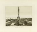
| Date: | 1872 |
|---|---|
| Description: | View of Milwaukee, looking southwest toward the county courthouse while it was under construction. |

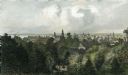
| Date: | 1886 |
|---|---|
| Description: | Bird's-eye view of Milwaukee from Bay View. |

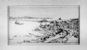
| Date: | 1854 |
|---|---|
| Description: | Bird's-eye view of Milwaukee looking east toward Lake Michigan from a bluff, long since graded into a slope, at about 6th Street between Wisconsin Avenue a... |
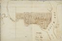
| Date: | |
|---|---|
| Description: | Map of "Navarino at the Head of Green Bay." Ousconsin Territory Daniel Whitney Proprietor. |
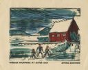
| Date: | 1949 |
|---|---|
| Description: | Holiday card of the Sister Bay lakeshore. Three figures are on the shore. Two boathouses, a covered boat, a pier, and two upright boats are in the backgrou... |
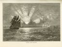
| Date: | 1874 |
|---|---|
| Description: | Engaved view depicting a dramatic sunset through clouds over Lake Michigan. Several sailing ships are in the foreground. |

| Date: | 1874 |
|---|---|
| Description: | Engraved view of downtown Racine seen from Lake Michigan. Several vessels are entering the harbor, and a pier with a beacon is on the right. |

| Date: | 1925 |
|---|---|
| Description: | This map shows lakes, islands and bays. The Upper Peninsula of Michigan and Ontario are labeled. Three inset maps include the Upper end of St. Marys River ... |

| Date: | 1975 |
|---|---|
| Description: | This map provides an index of outdated quadrangle maps for the state. Communities, counties, rivers, and lakes are labeled including Lake Michigan and Lake... |

| Date: | 1937 |
|---|---|
| Description: | Pictorial map showing historical events and locations within the state of Wisconsin, as well as waterways and counties. Original caption on the bottom marg... |

| Date: | 1855 |
|---|---|
| Description: | This map shows the locations of ancient works in the state of Wisconsin. Lake Superior and Michigan are labeled. Counties, towns, and rivers are also label... |

| Date: | 1853 |
|---|---|
| Description: | Map of a cross-section of southern Wisconsin, highlighting the La Crosse Milwaukee Rail Road. Shows canals, railroads, plank and post roads, and township g... |

| Date: | 1854 |
|---|---|
| Description: | This map shows the Manitowoc & Mississippi Railroad line along with other railroad lines in the Great Lakes Region. Lakes Superior, Michigan, Huron, Erie a... |

| Date: | 1947 |
|---|---|
| Description: | This map shows territorial roads laid out and opened between 1836 to 1848. Includes a scale in miles. Routes are labeled by numbers and indicated in key on... |

| Date: | 1950 |
|---|---|
| Description: | This map shows regions in Northern Illinois and Southern Wisconsin roughly bounded by Lake Winnebago, the Kankakee River, Peoria, and Prairie du Chien. The... |

| Date: | 1900 |
|---|---|
| Description: | This map shows the boundary lines between ceded and unceded land in compliance with the Treaty of Prairie du Chen of 1829. It also shows roads, rivers, por... |

| Date: | 1829 |
|---|---|
| Description: | This map shows waterways, trails, settlements, Indian villages, and boundaries. The map includes text in the lower left with excerpts from Indian land trea... |
If you didn't find the material you searched for, our Library Reference Staff can help.
Call our reference desk at 608-264-6535 or email us at: