 Filter: Categories of Wisconsin Historical Images
Filter: FORMAT_TYPE of prints, fine-art
Filter: Subject of intellectual life
Filter: Year of 1900-1999
Filter: Categories of Wisconsin Historical Images
Filter: FORMAT_TYPE of prints, fine-art
Filter: Subject of intellectual life
Filter: Year of 1900-1999
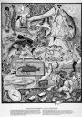
| Date: | 1987 |
|---|---|
| Description: | Imaginative pen-and-ink drawing titled, "Fish Tales (The Truth is Irrelevant, A Lie Well Told Lives Forever)." Sid adds the following words to describe the... |

| Date: | 1958 |
|---|---|
| Description: | This map shows state public hunting and/or fishing grounds, national forests, state forests, county forests.The lower margin includes an index to these loc... |

| Date: | 1982 |
|---|---|
| Description: | This map shows the location of major settlement regions for various ethnic groups. Includes a legend in lower left hand corner. Sparse settlement is repres... |

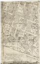
| Date: | 1911 |
|---|---|
| Description: | This map shows streets, railroads, the city house numbering system, and the Rock River. The left margin includes a street index. |
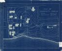
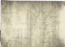
| Date: | 1905 |
|---|---|
| Description: | This blueprint map shows campus buildings, roads, and Lake Mendota. The compass rose near the title is incorrect; the map is actually oriented with north t... |

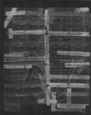
| Date: | 1913 |
|---|---|
| Description: | This photocopy map shows plots with owners' names, land use both commercial and agricultural, and lot outlines on University land. Lake Mendota is labeled ... |
| Date: | 1900 |
|---|---|
| Description: | This photocopy map shows the village in sections 23 and 24 of T19, R23E; later this area became part of the city of Manitowoc. The back of the map includes... |

| Date: | 1931 |
|---|---|
| Description: | This photocopy map shows lot and block numbers, some landownership and acreages, water flowage, and marshes. The map also shows Lake Menomin and Wilson Cr... |

| Date: | 1942 |
|---|---|
| Description: | This map shows a paper city laid out in 1836 on the Wisconsin River, now the site of Wyalusing State Park, Grant County. The upper right corner includes a ... |

| Date: | 1941 |
|---|---|
| Description: | This map shows heavy and light industry, residences, and business districts as well as streets and Mill Pond. The front and back of the map include extensi... |
| Date: | 1900 |
|---|---|
| Description: | This facsimile of manuscript map shows lot numbers, dimensions, streets, and township lines. The bottom left corner includes a certification. |
| Date: | 1900 |
|---|---|
| Description: | This facsimile of a manuscript map shows lots and streets. The lower left corner includes a certification. |

| Date: | 1900 |
|---|---|
| Description: | This photocopy plat map of a paper city on the southeastern shore of Green Bay, probably in Brown County. The front includes a registration and the back in... |

| Date: | 1910 |
|---|---|
| Description: | This set of manuscript blueprint maps show block and lot numbers, railroads, and some landownership, including lands and buildings of J.S. Owen Lumber Co. ... |

| Date: | 1926 |
|---|---|
| Description: | This blueprint map is oriented with north to the upper left. The map shows buildings with note of those "to be torn down," sidewalks, proposed power plant,... |

| Date: | 1937 |
|---|---|
| Description: | This cadastral map shows lots, streets, and Pell Lake. The back of the map includes a large advertisement for the Pell Lake Addition summer home lots. |

| Date: | 1900 |
|---|---|
| Description: | This manuscript map shows outline of Fort Winnebago reserve land, Fort Winnebago, claim of A. Grignon, and Indian boundaries. The Fox River and Swan Lake a... |

| Date: | 1917 |
|---|---|
| Description: | This road map shows routes through the state as well as some portions of Iowa, Minnesota, and Michigan. Cities, the Mississippi River, Lake Winnebago, Gree... |

| Date: | 1927 |
|---|---|
| Description: | This map details automobile routes throughout the state as well as parts of Iowa, Minnesota, Michigan and Illinois. Cities, the Mississippi River, Lake Mic... |

| Date: | 1910 |
|---|---|
| Description: | This map shows automobile routes across the state as well as Minnesota, Iowa, Illinois, and Michigan. Cities, Lake Michigan, Lake Superior, the Mississippi... |
If you didn't find the material you searched for, our Library Reference Staff can help.
Call our reference desk at 608-264-6535 or email us at: