 Filter: Categories of Wisconsin Historical Images
Filter: FORMAT_TYPE of prints, fine-art
Filter: Subject of intellectual life
Filter: Subject of religion
Filter: Categories of Wisconsin Historical Images
Filter: FORMAT_TYPE of prints, fine-art
Filter: Subject of intellectual life
Filter: Subject of religion
| Date: | |
|---|---|
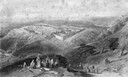
| Description: | Bird's-eye view of Jerusalem with the Muslim shrine, the Dome of the Rock, as seen from the hills outside the city. |
| Date: | 11 1970 |
|---|---|
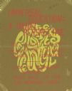
| Description: | Poster advertising a lecture by Dr. Dwight Allen, the Dean of the University of Massachusetts School of Education on the Baha'i perspective of universal ed... |
| Date: | 1860 |
|---|---|
| Description: | The devil holds the Texas state seal and a Confederate flag. "THE REBEL STATES" and "TEXAS" appear within the illustration. Blue ink on beige envelope, ima... |
| Date: | 1860 |
|---|---|
| Description: | The Devil sits on a bale labeled "COTTON." "No. 1" appears in the upper left corner. To the right is a verse that reads: "The Devil he sat with his c... |
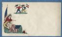
| Date: | 1860 |
|---|---|
| Description: | Jefferson Davis (J.D.) and General Beauregard (Gen. B) are carried by two running devils, the "Imps of Old Nick." Below is the caption and verse, "JE... |
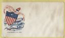
| Date: | 1860 |
|---|---|
| Description: | A rattlesnake labeled "SECESSION," with an arrow through its neck, is in front of a federal shield. The shield is protecting the Constitution and the Holy ... |
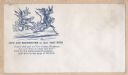
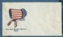
| Date: | 1860 |
|---|---|
| Description: | Three symbols appear from left to right, "God's" eye, the Union flag with a liberty cap on the top and the sun and clouds behind it, and a house. The capti... |
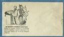
| Date: | 1860 |
|---|---|
| Description: | A clergyman stands at the pulpit with a bible on it, behind him stands the devil. Each has one hand on the open bible. The number 3 appears in the upper le... |
| Date: | 1861 |
|---|---|
| Description: | A Quaker bonnet made from the Union flag. It is unlikely that any practicing Quaker would have anything to do with a "Union bonnet" because of their belief... |
| Date: | 1860 |
|---|---|
| Description: | A cherub (angel) sits on a wagon with a bellows on top. He is blowing bubbles from a pipe. The newest bubble has the words " A ZEPHYR" in it (a zephyr is a... |
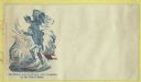
| Date: | 1860 |
|---|---|
| Description: | Jefferson Davis, holding a Confederate flag, is arriving in hell with a devil riding on his back. Another devil (Benedict Arnold) below is giving him a "wa... |
| Date: | 1860 |
|---|---|
| Description: | An angel holding a Union flag is saying "GOD WATCHES OVER THEM." Under her gaze two children peacefully sleep under a Union flag. At the foot of the bed an... |
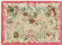
| Date: | 1895 |
|---|---|
| Description: | Valentine's Day card with three layers. The bottom layer is a pink and white card with embossed floral designs. The middle layer (not visible) is a country... |
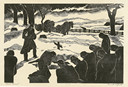
| Date: | |
|---|---|
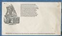
| Description: | Engraved view of a country burial in the snow. A clergyman reads a blessing as a mourner kneels near the grave. A group of mourners bow their heads. A team... |

| Date: | 1937 |
|---|---|
| Description: | Pictorial map showing historical events and locations within the state of Wisconsin, as well as waterways and counties. Original caption on the bottom marg... |

| Date: | 09 1894 |
|---|---|
| Description: | This map shows Congregational churches and Home Missionary churches. County boundaries and county seats are also labeled. The original caption reads, "Cong... |

| Date: | 1902 |
|---|---|
| Description: | This map shows townships, land parcels, schools, rivers, lakes, creameries, churches, cemeteries, roads, post offices, town halls, saw mills, roads and sto... |

| Date: | 1710 |
|---|---|
| Description: | A seminal and fairly accurate map of the Great Lakes Region up to Baffin's Bay in Northern Canada. This is possibly the first printed map to locate Detroit... |

| Date: | 1795 |
|---|---|
| Description: | Map of Connecticut showing counties, townships, cities, roads, islands, swamps, hills, mountains, lakes, rivers, reefs, and numerous other geographical and... |
If you didn't find the material you searched for, our Library Reference Staff can help.
Call our reference desk at 608-264-6535 or email us at: