 Filter: Categories of Wisconsin Historical Images
Filter: FORMAT_TYPE of prints, fine-art
Filter: Subject of intellectual life
Filter: Subject of cities and towns
Filter: Subject of water
Filter: Categories of Wisconsin Historical Images
Filter: FORMAT_TYPE of prints, fine-art
Filter: Subject of intellectual life
Filter: Subject of cities and towns
Filter: Subject of water

| Date: | 02 21 1882 |
|---|---|
| Description: | Chromolithograph poster advertising a Milwaukee Mardi Gras celebration, arranged by the Turnverein and Milwaukee Musical Societies, and held at the Exposit... |

| Date: | 1907 |
|---|---|
| Description: | Bird's-eye view of the University of Wisconsin-Madison campus looking northwest. Building at top of hill, to left of center is Bascom Hill (Main Hall) and... |

| Date: | 1879 |
|---|---|
| Description: | Bird's-eye view of Wisconsin State University, now the University of Wisconsin-Madison. Vignettes include Ladies Hall, South Dormitory, University Hall, As... |

| Date: | 1860 |
|---|---|
| Description: | Bird's-eye view of Janesville from the High School building. |
| Date: | 1882 |
|---|---|
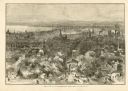
| Description: | Bird's-eye view of Milwaukee looking south down 8th Street from Schlitz's Park. |

| Date: | 1886 |
|---|---|
| Description: | Bird's-eye view of Milwaukee from Bay View. |

| Date: | 1857 |
|---|---|
| Description: | Bird's-eye view of Madison over rooftop and across lake with sailboats and steamers. A group of people are standing on a viewing platform on the roof in th... |

| Date: | 1854 |
|---|---|
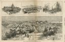
| Description: | Bird's-eye view of Milwaukee looking east toward Lake Michigan from a bluff, long since graded into a slope, at about 6th Street between Wisconsin Avenue a... |

| Date: | |
|---|---|
| Description: | Looking West from Knight Block, with shipping piers and sailing ships on right side, railroad on left, trees in background. Horse-drawn carriages on street... |
| Date: | 03 30 1889 |
|---|---|
| Description: | Bird's-eye view from Bascom Hill of Madison, with vignettes of the Wisconsin State Capitol, Lake Monona, and the Capitol Park. |

| Date: | 1884 |
|---|---|
| Description: | Panorama bird's-eye view of the town of Ashland, on Lake Superior, and the Apostle Islands. |

| Date: | 1917 |
|---|---|
| Description: | Bird's-eye view of the University of Wisconsin-Madison campus. |

| Date: | 1896 |
|---|---|
| Description: | This map shows railroads, ordinary roads, good roads, township lines, county lines, county boundaries, towns, lakes, and rivers in the southeastern part ... |

| Date: | 1898 |
|---|---|
| Description: | This map shows the conditions of the forest. Includes a color legend in left margin, depicting the various conditions. Original caption reads, "Compiled by... |

| Date: | 1916 |
|---|---|
| Description: | This map shows railroads, cities, rivers, lakes, and county boundaries. Select railroads are outlined in red. Portions of western Wisconsin Minnesota are v... |

| Date: | 1922 |
|---|---|
| Description: | This map shows public libraries, state traveling libraries, and county traveling libraries. County boundaries are labeled. Lake Michigan is on the far righ... |

| Date: | 1902 |
|---|---|
| Description: | This map shows townships, land parcels, schools, rivers, lakes, creameries, churches, cemeteries, roads, post offices, town halls, saw mills, roads and sto... |

| Date: | 1933 |
|---|---|
| Description: | A road map of Wisconsin, that shows the major and some minor roads of the state, population of the cities and towns, a scale and an index. The reverse side... |

| Date: | 1934 |
|---|---|
| Description: | This map features a road map with a legend and scale. The bigger cities and towns are highlighted in green. The back of the map includes an index, advertis... |

| Date: | 1934 |
|---|---|
| Description: | A road map of Wisconsin sponsored by Conoco. The front side includes and index, scale, and legend. The reverse side includes United States road map, and i... |
If you didn't find the material you searched for, our Library Reference Staff can help.
Call our reference desk at 608-264-6535 or email us at: