 Filter: Categories of Wisconsin Historical Images
Filter: FORMAT_TYPE of prints, fine-art
Filter: Subject of human settlements
Filter: Subject of transportation
Filter: Subject of lakes
Filter: Categories of Wisconsin Historical Images
Filter: FORMAT_TYPE of prints, fine-art
Filter: Subject of human settlements
Filter: Subject of transportation
Filter: Subject of lakes
| Date: | |
|---|---|
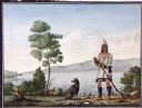
| Description: | Watercolor of Canadian Prairie Indian at lake's shore with gun in hand and a recently hunted duck on the ground. A dog is at his feet. On the far shoreline... |

| Date: | 1879 |
|---|---|
| Description: | Bird's-eye view of Wisconsin State University, now the University of Wisconsin-Madison. Vignettes include Ladies Hall, South Dormitory, University Hall, As... |

| Date: | 1857 |
|---|---|
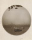
| Description: | Bird's-eye view of Madison over rooftop and across lake with sailboats and steamers. A group of people are standing on a viewing platform on the roof in th... |

| Date: | |
|---|---|
| Description: | Looking West from Knight Block, with shipping piers and sailing ships on right side, railroad on left, trees in background. Horse-drawn carriages on street... |
| Date: | |
|---|---|
| Description: | Wisconsin Capital from the shores of Lake Mendota, with two steamboats crossing the lake. |
| Date: | |
|---|---|
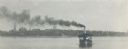
| Description: | Steamboat on Lake Monona, with the Wisconsin State Capitol and several churches in the background. |
| Date: | 1895 |
|---|---|
| Description: | View of the Tonyawatha Spring Hotel grounds, located on Lake Monona in Blooming Grove Township, just outside of Madison. The hotel opened in 1879 and on Ju... |
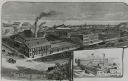
| Date: | 1883 |
|---|---|
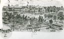
| Description: | Etched print of factory with inset of Bay State Works in lower right corner. Lake with ships in background, with busy, buggy covered roads in foreground. ... |

| Date: | 1917 |
|---|---|
| Description: | Bird's-eye view of the University of Wisconsin-Madison campus. |
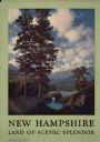
| Date: | 1936 |
|---|---|
| Description: | An original lithograph promoting New Hampshire as the "Land of Scenic Splendor." The poster features the artist Maxwell Parrish's depiction of a New Hampsh... |

| Date: | 1900 |
|---|---|
| Description: | A map of La Crosse County, Wisconsin, showing and identifying the townships and section numbers, towns, cities and villages, landowners, rivers, railroads,... |

| Date: | 1898 |
|---|---|
| Description: | This 1898 map of Sawyer County, Wisconsin, shows the township and range system, sections, roads, farm houses, camps, school houses, dams, bridges, Indian r... |

| Date: | 1930 |
|---|---|
| Description: | Lower left hand corner reads: "Compliment of the Madison Association of Commerce MADISON The Four Lake City WISCONSIN." Around the perimeter of the map is ... |

| Date: | 1937 |
|---|---|
| Description: | Includes points of interests in Madison and on the University of Wisconsin-Madison campus. Includes list of presidents of University of Wisconsin, 1849-193... |

| Date: | 1975 |
|---|---|
| Description: | This map provides an index of outdated quadrangle maps for the state. Communities, counties, rivers, and lakes are labeled including Lake Michigan and Lake... |

| Date: | 1853 |
|---|---|
| Description: | Map of a cross-section of southern Wisconsin, highlighting the La Crosse Milwaukee Rail Road. Shows canals, railroads, plank and post roads, and township g... |

| Date: | 1947 |
|---|---|
| Description: | This map shows territorial roads laid out and opened between 1836 to 1848. Includes a scale in miles. Routes are labeled by numbers and indicated in key on... |

| Date: | 1829 |
|---|---|
| Description: | This map shows waterways, trails, settlements, Indian villages, and boundaries. The map includes text in the lower left with excerpts from Indian land trea... |

| Date: | 1856 |
|---|---|
| Description: | This map shows the railroad routes and connection of the Mineral Point Railroad. Lake Michigan is on the far right, while Lake Superior is at the top of th... |

| Date: | 1856 |
|---|---|
| Description: | This map shows the railroad routes that lead to Milwaukee. Included are portions of Minnesota, Iowa and Illinois. Lake Michigan is on the right, while Lake... |
If you didn't find the material you searched for, our Library Reference Staff can help.
Call our reference desk at 608-264-6535 or email us at: