 Filter: Categories of Wisconsin Historical Images
Filter: FORMAT_TYPE of prints, fine-art
Filter: Subject of human settlements
Filter: Subject of lakes
Filter: County of Milwaukee
Filter: Categories of Wisconsin Historical Images
Filter: FORMAT_TYPE of prints, fine-art
Filter: Subject of human settlements
Filter: Subject of lakes
Filter: County of Milwaukee
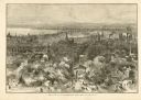
| Date: | 1882 |
|---|---|
| Description: | Bird's-eye view of Milwaukee looking south down 8th Street from Schlitz's Park. |
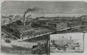
| Date: | 1883 |
|---|---|
| Description: | Etched print of factory with inset of Bay State Works in lower right corner. Lake with ships in background, with busy, buggy covered roads in foreground. ... |

| Date: | 1900 |
|---|---|
| Description: | This map shows landownership, railroads, roads, churches, schools, cemeteries, post offices, townships, city wards, Lake Michigan, and rivers. The map incl... |

| Date: | 1837 |
|---|---|
| Description: | This map shows the proposed Rock River Canal, between Milwaukee County thru the west line of what is now Waukesha County. Also shows townships, roads, hydr... |
If you didn't find the material you searched for, our Library Reference Staff can help.
Call our reference desk at 608-264-6535 or email us at: