 Filter: Categories of Wisconsin Historical Images
Filter: FORMAT_TYPE of prints, fine-art
Filter: Subject of hotels
Filter: Categories of Wisconsin Historical Images
Filter: FORMAT_TYPE of prints, fine-art
Filter: Subject of hotels
| Date: | |
|---|---|
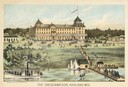
| Description: | Lithograph depicting the Chequamegon Hotel from the Ashland harbor. |
| Date: | 1853 |
|---|---|
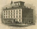
| Description: | Illustration of the Capital house, a first-class hotel, copied from page 320 of Gleason's Pictorial Drawing-Room Companion. |
| Date: | 1895 |
|---|---|
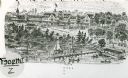
| Description: | View of the Tonyawatha Spring Hotel grounds, located on Lake Monona in Blooming Grove Township, just outside of Madison. The hotel opened in 1879 and on Ju... |
| Date: | 1932 |
|---|---|
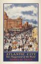
| Description: | An original lithograph promoting Atlantic City as "the playground of the world," and to get there by way of train travel. The poster depicts the buildings ... |

| Date: | 05 1854 |
|---|---|
| Description: | This yellow and black wood block print broadside ties England and France's declaration of war against Russia during the Crimean War into a war against high... |

| Date: | 1864 |
|---|---|
| Description: | This map is pen and watercolor on paper and shows a profile and the geological formation of Blue Mound. Also shown is the location of Arnold's Hotel and Br... |

| Date: | 1935 |
|---|---|
| Description: | This blue lined map shows the major roads and cities of Wisconsin. The map includes an index, hotel and cafe advertisements, as well as advertisements for ... |

| Date: | 1935 |
|---|---|
| Description: | This blue lined map ("compliments of Black Eagle Oil Company") shows the major roads and cities of Wisconsin. The map includes an index, hotel and cafe adv... |

| Date: | 1937 |
|---|---|
| Description: | This map shows the major cities, towns, highways, roads, lakes, and rivers of Wisconsin and some of the neighboring states. An index is included on the fro... |

| Date: | 1941 |
|---|---|
| Description: | This map highlights the fishing district and shows labeled rivers, lakes, cities, county boundaries and points of interest. The map includes a list of trai... |
If you didn't find the material you searched for, our Library Reference Staff can help.
Call our reference desk at 608-264-6535 or email us at: