 Filter: Categories of Wisconsin Historical Images
Filter: FORMAT_TYPE of prints, fine-art
Filter: Subject of clergy
Filter: Categories of Wisconsin Historical Images
Filter: FORMAT_TYPE of prints, fine-art
Filter: Subject of clergy
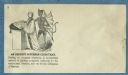
| Date: | 1860 |
|---|---|
| Description: | A clergyman stands at the pulpit with a bible on it, behind him stands the devil. Each has one hand on the open bible. The number 3 appears in the upper le... |
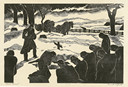
| Date: | |
|---|---|
| Description: | Engraved view of a country burial in the snow. A clergyman reads a blessing as a mourner kneels near the grave. A group of mourners bow their heads. A team... |

| Date: | 1710 |
|---|---|
| Description: | A seminal and fairly accurate map of the Great Lakes Region up to Baffin's Bay in Northern Canada. This is possibly the first printed map to locate Detroit... |

| Date: | 1718 |
|---|---|
| Description: | This map shows the Mississippi River, with latitude and longitude coordinates, ad covers east to Lake Ontario and south to Illinois. The inset map (the top... |
If you didn't find the material you searched for, our Library Reference Staff can help.
Call our reference desk at 608-264-6535 or email us at: