 Filter: Categories of Wisconsin Historical Images
Filter: FORMAT_TYPE of prints, fine-art
Filter: Subject of camps
Filter: Categories of Wisconsin Historical Images
Filter: FORMAT_TYPE of prints, fine-art
Filter: Subject of camps
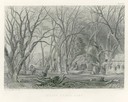
| Date: | 1850 |
|---|---|
| Description: | Chippewa Indian Sugar Camp. Plate 61, preceding p. 199, vol. I, The Indian tribes of the United States: their history antiquities, customs, religion, ar... |

| Date: | 1927 |
|---|---|
| Description: | Blueprint-style map of Frost Woods on the shore of Lake Monona. The map indicates the locations of Indian mounds, an Indian camp, and various plants. There... |
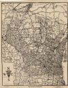
| Date: | 1924 |
|---|---|
| Description: | This map shows roads, cities, rivers,lakes, road surfacings and camp sites. Included are portions of Minnesota, Iowa, Illinois, and Michigan. Includes a le... |

| Date: | 1941 |
|---|---|
| Description: | This map highlights the fishing district and shows labeled rivers, lakes, cities, county boundaries and points of interest. The map includes a list of trai... |
If you didn't find the material you searched for, our Library Reference Staff can help.
Call our reference desk at 608-264-6535 or email us at:
