 Filter: Categories of Wisconsin Historical Images
Filter: FORMAT_TYPE of prints, fine-art
Filter: County of Dane
Filter: Subject of buildings
Filter: Categories of Wisconsin Historical Images
Filter: FORMAT_TYPE of prints, fine-art
Filter: County of Dane
Filter: Subject of buildings

| Date: | 1857 |
|---|---|
| Description: | Bird's-eye view of Madison over rooftop and across lake with sailboats and steamers. A group of people are standing on a viewing platform on the roof in th... |

| Date: | 1918 |
|---|---|
| Description: | This is a collection of two maps. One map is blue line print that includes illustrations and shows the location of buildings, gardens, plant life, and spri... |

| Date: | 05 14 1886 |
|---|---|
| Description: | Printed announcement of the opening of the Madison Fire Department. At the top, in a circular frame, is a fire fighter driving a horse-drawn fire engine. B... |
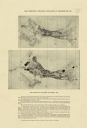
| Date: | 1918 |
|---|---|
| Description: | The map on the top shows the building situation in Madison in 1899, while the bottom map shows the building situation in 1916. Includes text in the lower m... |

| Date: | 1905 |
|---|---|
| Description: | This blueprint map shows buildings and roads on Bascom Hill. University Avenue, Park street, Charter Street, and Lincoln Drive are labeled. Lake Mendota is... |
If you didn't find the material you searched for, our Library Reference Staff can help.
Call our reference desk at 608-264-6535 or email us at: