Filter: Categories of Wisconsin Historical Images
Filter: FORMAT_TYPE of prints, fine-art
Filter: County of Dane
Filter: Creator Name of Unknown
Filter: Subject of cities and towns
Filter: Categories of Wisconsin Historical Images
Filter: FORMAT_TYPE of prints, fine-art
Filter: County of Dane
Filter: Creator Name of Unknown
Filter: Subject of cities and towns
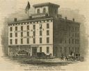
| Date: | 1853 |
|---|---|
| Description: | Illustration of the Capital house, a first-class hotel, copied from page 320 of Gleason's Pictorial Drawing-Room Companion. |
| Date: | |
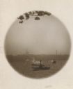
|---|---|
| Description: | Wisconsin Capital from the shores of Lake Mendota, with two steamboats crossing the lake. |
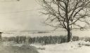
| Date: | 1915 |
|---|---|
| Description: | Picnic Point from Observatory Hill in winter. |
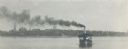
| Date: | |
|---|---|
| Description: | Steamboat on Lake Monona, with the Wisconsin State Capitol and several churches in the background. |
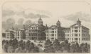
| Date: | 1874 |
|---|---|
| Description: | Wisconsin State Hospital for the Insane (Mendota Mental Health Institute) near Madison. |
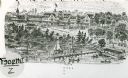
| Date: | 1895 |
|---|---|
| Description: | View of the Tonyawatha Spring Hotel grounds, located on Lake Monona in Blooming Grove Township, just outside of Madison. The hotel opened in 1879 and on Ju... |

| Date: | 09 05 1971 |
|---|---|
| Description: | Poster advertising the "Second Annual Day of Interdependence Comemerating [sic] the Declaration of Miffland." Features a caricatured Mifflin Co-op and two ... |

| Date: | 1927 |
|---|---|
| Description: | Blueprint-style map of Frost Woods on the shore of Lake Monona. The map indicates the locations of Indian mounds, an Indian camp, and various plants. There... |

| Date: | 1861 |
|---|---|
| Description: | The township of Primrose, which is a detail from the plat map of Dane County. |

| Date: | 1861 |
|---|---|
| Description: | The township of Montrose, which is a detail from a Dane County plat map. |

| Date: | 1910 |
|---|---|
| Description: | This blueprint plat map shows the plan of lots and streets on a Madison hill south of Lake Monona. Includes annotations showing land prices in pencil. |

| Date: | 1914 |
|---|---|
| Description: | This blueprint map includes manuscript annotations in red and shows number of acres and dates of acquisition (1905-1914) of each parcel of land, as well as... |

| Date: | 1877 |
|---|---|
| Description: | Engraving of the Peck Cabin, after the painting by Mrs. E.E. Bailey. Caption at bottom reads: "First House in Madison. 1837." |

| Date: | 1905 |
|---|---|
| Description: | This blueprint map includes manuscript annotations in red showing land of Home Realty Co., Hon. Geo. B. Burrows, and A.O. Fox Industrial. |
If you didn't find the material you searched for, our Library Reference Staff can help.
Call our reference desk at 608-264-6535 or email us at: