 Filter: Categories of Wisconsin Historical Images
Filter: FORMAT_TYPE of prints, fine-art
Filter: County of Columbia
Filter: Categories of Wisconsin Historical Images
Filter: FORMAT_TYPE of prints, fine-art
Filter: County of Columbia

| Date: | 1831 |
|---|---|
| Description: | Drawing of Fort Winnebago (near present-day Portage) that illustrated "Wau-Bun," Juliette Kinzie's memoir of her experiences on the early Wisconsin fronti... |
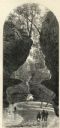
| Date: | 1874 |
|---|---|
| Description: | Engraved view of Rood's Glen. A boy plays with a toy boat at bottom left while two men and a woman talk at bottom right. Two other figures can be seen in t... |

| Date: | 1854 |
|---|---|
| Description: | Register of the Deed Office filed by the land surveyor and lawyer Alfred Topliff. The document includes detailed listings of city blocks. In the right hand... |

| Date: | 1900 |
|---|---|
| Description: | This manuscript map shows outline of Fort Winnebago reserve land, Fort Winnebago, claim of A. Grignon, and Indian boundaries. The Fox River and Swan Lake a... |
If you didn't find the material you searched for, our Library Reference Staff can help.
Call our reference desk at 608-264-6535 or email us at: