 Filter: Categories of Wisconsin Historical Images
Filter: FORMAT_TYPE of prints, fine-art
Filter: Community of Madison
Filter: Categories of Wisconsin Historical Images
Filter: FORMAT_TYPE of prints, fine-art
Filter: Community of Madison

| Date: | 1905 |
|---|---|
| Description: | This blueprint map shows buildings and roads on Bascom Hill. University Avenue, Park street, Charter Street, and Lincoln Drive are labeled. Lake Mendota is... |

| Date: | 1910 |
|---|---|
| Description: | This blueprint plat map shows the plan of lots and streets on a Madison hill south of Lake Monona. Includes annotations showing land prices in pencil. |

| Date: | 1929 |
|---|---|
| Description: | This plat map shows land parcels, blocks and streets located in a portion of the Mendota Beach subdivision. Streets include Adelia Street, Wesley Avenue, B... |

| Date: | 1914 |
|---|---|
| Description: | This blueprint map includes manuscript annotations in red and shows number of acres and dates of acquisition (1905-1914) of each parcel of land, as well as... |

| Date: | 03 15 1974 |
|---|---|
| Description: | Poster for "Art Sale for Soglin" at Gallery 853, 853 Williamson Street. In the center is a head and shoulders posterized portrait of Paul Soglin silk-scree... |
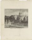
| Date: | 1878 |
|---|---|
| Description: | This frontispiece lithograph shows the State Capitol with an American flag on flying on top of the dome. The grounds include trees and paths and are enclos... |

| Date: | 1890 |
|---|---|
| Description: | This map oriented with north towards the upper right shows sewers, cases of diphtheria and scarlet fever, schools, and public buildings. Lake Wingra is lab... |

| Date: | 1925 |
|---|---|
| Description: | This map oriented with north to the upper right and shows 14 overlapping school districts. From left to right the schools include: Randall, Longfellow, Fra... |

| Date: | 1925 |
|---|---|
| Description: | This map oriented with north to the upper right shows 12 school districts of new proposed schools and existing schools. From left to right existing schools... |
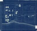
| Date: | 1905 |
|---|---|
| Description: | This blueprint map shows campus buildings, roads, and Lake Mendota. The compass rose near the title is incorrect; the map is actually oriented with north t... |

| Date: | 1913 |
|---|---|
| Description: | This photocopy map shows plots with owners' names, land use both commercial and agricultural, and lot outlines on University land. Lake Mendota is labeled ... |

| Date: | 1877 |
|---|---|
| Description: | Engraving of the Peck Cabin, after the painting by Mrs. E.E. Bailey. Caption at bottom reads: "First House in Madison. 1837." |

| Date: | 1905 |
|---|---|
| Description: | This blueprint map includes manuscript annotations in red showing land of Home Realty Co., Hon. Geo. B. Burrows, and A.O. Fox Industrial. |

| Date: | 1984 |
|---|---|
| Description: | Silk-screen print of University of Wisconsin-Madison mascot, Bucky Badger, in red ink on white paper. Bucky is running, and is wearing a striped sweater an... |

| Date: | 1932 |
|---|---|
| Description: | Formal printed quarter-length portrait of Wisconsin Secretary of State Theodore Dammann. |

| Date: | 02 10 1986 |
|---|---|
| Description: | Silkscreen poster announcing the Fifteen Hundred Little Pictures Polaroid Photography show. The photographers names are Joann Jensen, Mark Porter and Mike ... |
If you didn't find the material you searched for, our Library Reference Staff can help.
Call our reference desk at 608-264-6535 or email us at: