Filter: Categories of Wisconsin Historical Images
Filter: FORMAT_TYPE of photographic print, b
Filter: Subject of real estate development
Filter: Categories of Wisconsin Historical Images
Filter: FORMAT_TYPE of photographic print, b
Filter: Subject of real estate development

| Date: | 1898 |
|---|---|
| Description: | University Heights from the Chemistry Building on University Avenue. View includes the University of Wisconsin-Madison football field, on the former site o... |

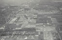
| Date: | 06 07 1954 |
|---|---|
| Description: | Aerial view of the Midvale neighborhood under construction showing the intersection of Midvale and Tokay Boulevards near the southwestern city limits of Ma... |

| Date: | 06 07 1954 |
|---|---|
| Description: | Aerial view looking north from near the city's southwestern limits in 1954. Shows text indicating Midvale Boulevard, Odana Road, Tokay Boulevard, Mineral P... |

| Date: | 1955 |
|---|---|
| Description: | Aerial view of Midvale neighborhood under construction near Madison's southwestern city limits. The view is focused on the area bounded by Tokay Boulevard,... |
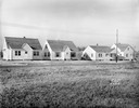
| Date: | 11 23 1938 |
|---|---|
| Description: | A row of houses at 826, 830, 834 & 838 North Fair Oaks Avenue built by the Fitzpatrick Lumber Company in what was the Town of Blooming Grove, now near East... |
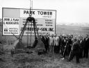
| Date: | |
|---|---|
| Description: | Developers, local dignitaries, and other businessmen participate in a ground-breaking ceremony for the construction of the Park Tower Apartments. |

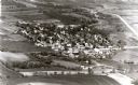
| Date: | 1956 |
|---|---|
| Description: | Aerial view looking south from a point over the Maple Bluff country club golf course (foreground). A new housing development in the mid-ground and Maple Bl... |
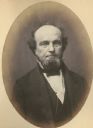
| Date: | 1858 |
|---|---|
| Description: | Morgan L. Martin (1805-1887), Wisconsin lawyer, judge, politician, land speculator, and one of the leading figures in early Wisconsin history. Martin sett... |
| Date: | 06 1972 |
|---|---|
| Description: | View along the 2700 block of Fish Hatchery Road, with billboard advertising residential lots in Tower Hill Park (a development by Llyman McKee and William ... |

| Date: | |
|---|---|
| Description: | Aerial view of Vieth's Park subdivision on the north shore of Lake Mendota. |

| Date: | 10 30 1915 |
|---|---|
| Description: | Outdoor group portrait of people identified as "settlers" (lot buyers) to the Nakoma development. Many of the people are wearing or holding a long-stemmed ... |

| Date: | |
|---|---|
| Description: | View across field or vacant lot of grass towards the Stanley Hanks bungalows located at 211-219 Lake Lawn Place off Langdon Street. Hanks probably built th... |
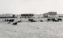
| Date: | |
|---|---|
| Description: | View toward a group o people gathered at a vacant lot. There are dwellings in the distance. Caption reads: "Lot Sale on Sub-Division, Granton, Wis." |

| Date: | 1962 |
|---|---|
| Description: | Aerial view of the Hilldale Shopping Center and environs. Anchor store is Gimbels. N. Midvale Boulevard runs left to right. The State Department of Transpo... |

| Date: | 1967 |
|---|---|
| Description: | Air view looking north toward Lake Mendota. The intersection of West Washington Ave. and S. Park Street is at bottom center. The Triangle Redevelopment Pro... |
If you didn't find the material you searched for, our Library Reference Staff can help.
Call our reference desk at 608-264-6535 or email us at: