Filter: Categories of Wisconsin Historical Images
Filter: FORMAT_TYPE of photographic print, b
Filter: Subject of cities and towns
Filter: Community of Green Bay
Filter: Categories of Wisconsin Historical Images
Filter: FORMAT_TYPE of photographic print, b
Filter: Subject of cities and towns
Filter: Community of Green Bay

| Date: | 1851 |
|---|---|
| Description: | A rare photograph of U.S. Army soldiers stationed at Fort Howard rowing a boat on the Fox River. Fort Howard, built in 1816, was the first in the chain of ... |
| Date: | 1952 |
|---|---|
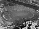
| Description: | Aerial view of City Stadium, former home of the Green Bay Packers from 1925 to 1956. Currently it is the home of the Green Bay East High School football te... |
| Date: | 12 31 1961 |
|---|---|
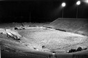
| Description: | Workmen, shivering in the 6 a.m. predawn cold, remove hay from the field at Green Bay City Stadium (now Lambeau Field) before the NFL championship game bet... |

| Date: | 1867 |
|---|---|
| Description: | Bird's-eye map of Green Bay and Fort Howard, Brown Co., depicts street names and street layouts, houses, trees, and the East River. A reference key at the ... |
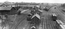
| Date: | 1930 |
|---|---|
| Description: | Elevated view of the Green Bay & Western Railroad roundhouse. |
| Date: | 1930 |
|---|---|
| Description: | Elevated view of the Chicago, Milwaukee & St. Paul Railway yard and roundhouse (left) on South Oakland Avenue. |
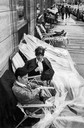
| Date: | 07 20 1970 |
|---|---|
| Description: | Packer fans, despite bad weather, wait in line Sunday outside The Milwaukee Journal Company building to wait for Monday's football ticket sale. First in li... |
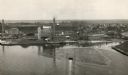
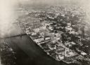
| Date: | 1920 |
|---|---|
| Description: | Aerial view of the conluence of the Fox River and the East River. The Northern Paper Mills are in the foreground and the city is seen to the right. |

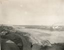
| Date: | 1955 |
|---|---|
| Description: | Aerial view of river and its surrounding landscape. |

| Date: | 1950 |
|---|---|
| Description: | Aerial view of fields near neighborhoods. |

| Date: | 1950 |
|---|---|
| Description: | Aerial view of the confluence of the Fox River and Green Bay. |
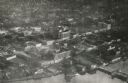
| Date: | 1948 |
|---|---|
| Description: | Aerial view of downtown area, with the Fox River and neighboring suburbs. |
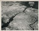
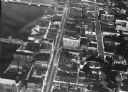
| Date: | 1920 |
|---|---|
| Description: | Aerial view of the commercial district on the east side of the Fox River. Left to right: Hurlbut Coal Company; suggested location for small terminal; Main... |
| Date: | 1924 |
|---|---|
| Description: | Aerial view of Green Bay's commercial district, bridges, and water. |
| Date: | 1920 |
|---|---|
| Description: | Aerial view of Green Bay's commercial district on the Fox River. |

| Date: | 1950 |
|---|---|
| Description: | Aerial view of the Fox River, near Green Bay. Handwritten locations are marked, including: Site of First Court House, Little Rapids, De Pere. |
| Date: | 1920 |
|---|---|
| Description: | Aerial view with fishing piers, coal factories, a bridge, and railroad tracks. |
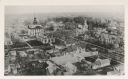
| Date: | 1890 |
|---|---|
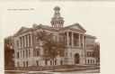
| Description: | Aerial view of downtown Green Bay, with the old Court House. |
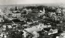
| Date: | 1890 |
|---|---|
| Description: | Aerial view of downtown Green Bay with old Court House and the surrounding buildings. |
If you didn't find the material you searched for, our Library Reference Staff can help.
Call our reference desk at 608-264-6535 or email us at: